Koreatown geodata
Koreatown (California) is a section of populated place; located in United States in America/Los_Angeles (GMT-7) time zone. With population of 124,281 people, there are 252 cities with bigger population in this country. Compared to other cities in United States, 79.8% of cities are located further ↑North; 91.3% of cities are located further →East and 76.2% of cities have higher elevation than Koreatown. Note1


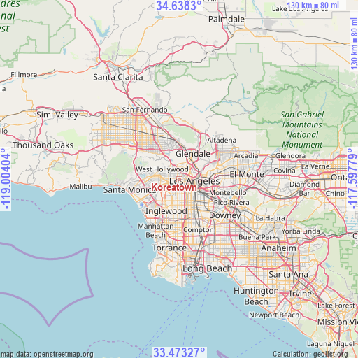
Koreatown GPS coordinates[2]
34° 3' 28.044" North, 118° 18' 3.276" West
| Map corner | latitude | longitude |
|---|---|---|
| Upper-left | 34.6383°, | -119.00404° |
| Center: | 34.05779°, | -118.30091° |
| Lower-right: | 33.47327°, | -117.59779° |
| Map W x H: | 129.5×129.5 km | = 80.5×80.5mi |
| max Lat: | 71.29058° ⇑79.8% North |
| Koreatown: | 34.05779° |
| min Lat: | ⇓20.2% South 19.06759° |
| min Long | Koreatown | max Long |
| -171.73463° | -118.30091° | -66.98998° |
| W 8.7%⇐ | ⇒91.3% E |
Elevation
Elevation of Koreatown is 65 m = 213 ft, and this is 229.8 m = 754 ft below average elevation for this country.
| Max E: |
3189 m = 10463 ft | 76.2% |
| Avg. | 294.8 m = 967 ft | |
| Koreatown | 65 m = 213 ft | |
Min E: |
-60 m = -197 ft | 23.8% |
See also: Koreatown elevation on elevation.city.
Geographical zone
Koreatown is located in North temperate zone (between Tropic of Cancer and the Arctic Circle). Distance of this Northern Tropic circle is 1181 km =733.8 mi to South.| Distance of | km | miles | from Koreatown |
|---|---|---|---|
| North Pole | 6220.2 | 3865.1 | to North |
| Arctic Circle | 3614.3 | 2245.8 | to North |
| Tropic Cancer | 1181 | 733.8 | to South |
| Equator | 3786.9 | 2353.1 | to South |


Nearby cities:
15 places around Koreatown: (largest is in red/bold)
• Beverly Hills
9.3 km =5.8 mi,  280°
280°
• Boyle Heights
9.2 km =5.7 mi,  106°
106°
• Century City
10.8 km =6.7 mi,  268°
268°
• Culver City
9.7 km =6 mi,  245°
245°
• Echo Park
4.3 km =2.7 mi,  58°
58°
• Florence-Graham
11.3 km =7 mi,  152°
152°
• Glendale
10.3 km =6.4 mi,  24°
24°
• Hollywood
5.1 km =3.2 mi,  332°
332°
• Huntington Park
11 km =6.8 mi,  140°
140°
• Ladera Heights
9.9 km =6.2 mi,  224°
224°
• Los Angeles
5.3 km =3.3 mi,  96°
96°
• Silver Lake
4.3 km =2.7 mi,  41°
41°
• Universal City
10.2 km =6.3 mi, 331°
• View Park-Windsor Hills
8.2 km =5.1 mi,  212°
212°
• West Hollywood
6.6 km =4.1 mi,  302°
302°
Sources, notices
• [Note1] Compared only with cities in United States existing in our database
• [Src1] Map data: © OpenStreetMap contributors (CC-BY-SA)
• [Src2] Other city data from geonames.org with taken over terms of usage.
• [Src3] Geographical zone / Annual Mean Temperature by Robert A. Rohde @ Wikipedia
