London geodata
London (California) is a populated place; located in United States in America/Los_Angeles (GMT-7) time zone. With population of 1,869 people, there are 12312 cities with bigger population in this country. Compared to other cities in United States, 68.1% of cities are located further ↑North; 92.3% of cities are located further →East and 71.3% of cities have higher elevation than London. Note1


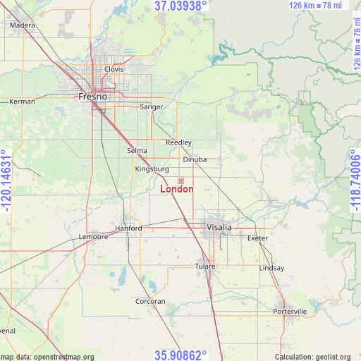
London GPS coordinates[2]
36° 28' 33.816" North, 119° 26' 35.448" West
| Map corner | latitude | longitude |
|---|---|---|
| Upper-left | 37.03938°, | -120.14631° |
| Center: | 36.47606°, | -119.44318° |
| Lower-right: | 35.90862°, | -118.74006° |
| Map W x H: | 125.7×125.7 km | = 78.1×78.1mi |
| max Lat: | 71.29058° ⇑68.1% North |
| London: | 36.47606° |
| min Lat: | ⇓31.9% South 19.06759° |
| min Long | London | max Long |
| -171.73463° | -119.44318° | -66.98998° |
| W 7.7%⇐ | ⇒92.3% E |
Elevation
Elevation of London is 93 m = 305 ft, and this is 201.8 m = 662 ft below average elevation for this country.
| Max E: |
3189 m = 10463 ft | 71.3% |
| Avg. | 294.8 m = 967 ft | |
| London | 93 m = 305 ft | |
Min E: |
-60 m = -197 ft | 28.7% |
See also: United States elevation on elevation.city.
Geographical zone
London is located in North temperate zone (between Tropic of Cancer and the Arctic Circle). Distance of this Northern Tropic circle is 1449.8 km =900.9 mi to South.| Distance of | km | miles | from London |
|---|---|---|---|
| North Pole | 5951.3 | 3698 | to North |
| Arctic Circle | 3345.4 | 2078.7 | to North |
| Tropic Cancer | 1449.8 | 900.9 | to South |
| Equator | 4055.8 | 2520.2 | to South |


Nearby cities:
15 places around London: (largest is in red/bold)
• Cutler
14.9 km =9.3 mi,  69°
69°
• Dinuba
9 km =5.6 mi,  33°
33°
• Goshen
14.1 km =8.8 mi,  171°
171°
• Ivanhoe
22.4 km =13.9 mi,  116°
116°
• Kingsburg
10.8 km =6.7 mi,  292°
292°
• Laton
22.3 km =13.9 mi,  257°
257°
• Orange Cove
20.1 km =12.5 mi,  35°
35°
• Orosi
15.9 km =9.9 mi,  61°
61°
• Parlier
16.8 km =10.4 mi,  333°
333°
• Patterson Tract
17 km =10.6 mi,  129°
129°
• Reedley
13.4 km =8.3 mi,  357°
357°
• Selma
18.4 km =11.4 mi,  304°
304°
• Sultana
12 km =7.5 mi,  50°
50°
• Traver
4.4 km =2.7 mi,  238°
238°
• Visalia
21.1 km =13.1 mi,  140°
140°
Sources, notices
• [Note1] Compared only with cities in United States existing in our database
• [Src1] Map data: © OpenStreetMap contributors (CC-BY-SA)
• [Src2] Other city data from geonames.org with taken over terms of usage.
• [Src3] Geographical zone / Annual Mean Temperature by Robert A. Rohde @ Wikipedia
