Madera geodata
Madera (California) is a seat of a second-order administrative division; located in United States in America/Los_Angeles (GMT-7) time zone. With population of 64,208 people, there are 676 cities with bigger population in this country. Compared to other cities in United States, 66.3% of cities are located further ↑North; 92.9% of cities are located further →East and 72.3% of cities have higher elevation than Madera. Note1


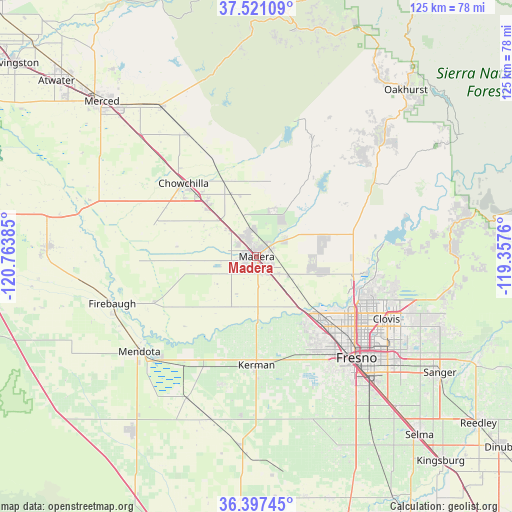
Madera GPS coordinates[2]
36° 57' 40.824" North, 120° 3' 38.592" West
| Map corner | latitude | longitude |
|---|---|---|
| Upper-left | 37.52109°, | -120.76385° |
| Center: | 36.96134°, | -120.06072° |
| Lower-right: | 36.39745°, | -119.3576° |
| Map W x H: | 124.9×124.9 km | = 77.6×77.6mi |
| max Lat: | 71.29058° ⇑66.3% North |
| Madera: | 36.96134° |
| min Lat: | ⇓33.7% South 19.06759° |
| min Long | Madera | max Long |
| -171.73463° | -120.06072° | -66.98998° |
| W 7.1%⇐ | ⇒92.9% E |
Elevation
Elevation of Madera is 87 m = 285 ft, and this is 207.8 m = 682 ft below average elevation for this country.
| Max E: |
3189 m = 10463 ft | 72.3% |
| Avg. | 294.8 m = 967 ft | |
| Madera | 87 m = 285 ft | |
Min E: |
-60 m = -197 ft | 27.7% |
See also: Madera elevation on elevation.city.
Geographical zone
Madera is located in North temperate zone (between Tropic of Cancer and the Arctic Circle). Distance of this Northern Tropic circle is 1503.8 km =934.4 mi to South.| Distance of | km | miles | from Madera |
|---|---|---|---|
| North Pole | 5897.3 | 3664.4 | to North |
| Arctic Circle | 3291.5 | 2045.2 | to North |
| Tropic Cancer | 1503.8 | 934.4 | to South |
| Equator | 4109.7 | 2553.6 | to South |


Nearby cities:
15 places around Madera: (largest is in red/bold)
• Biola
18.1 km =11.2 mi,  167°
167°
• Bonadelle Ranchos-Madera Ranchos
16.7 km =10.4 mi,  81°
81°
• Chowchilla
25.2 km =15.7 mi,  315°
315°
• Clovis
35.2 km =21.9 mi,  115°
115°
• Fairmead
17.4 km =10.8 mi, 317°
• Fresno
35 km =21.7 mi,  132°
132°
• Friant
31.1 km =19.3 mi, 84°
• Kerman
26.4 km =16.4 mi,  179°
179°
• Le Grand
34 km =21.1 mi,  330°
330°
• Madera Acres
6.4 km =4 mi,  355°
355°
• Old Fig Garden
29 km =18 mi, 128°
• Parksdale
3.7 km =2.3 mi, 115°
• Parkwood
4.1 km =2.5 mi,  159°
159°
• Rolling Hills
24.3 km =15.1 mi,  105°
105°
• West Park
33.6 km =20.9 mi,  146°
146°
Sources, notices
• [Note1] Compared only with cities in United States existing in our database
• [Src1] Map data: © OpenStreetMap contributors (CC-BY-SA)
• [Src2] Other city data from geonames.org with taken over terms of usage.
• [Src3] Geographical zone / Annual Mean Temperature by Robert A. Rohde @ Wikipedia
