Chowchilla geodata
Chowchilla (California) is a populated place; located in United States in America/Los_Angeles (GMT-7) time zone. With population of 18,510 people, there are 2712 cities with bigger population in this country. Compared to other cities in United States, 65.6% of cities are located further ↑North; 93.1% of cities are located further →East and 74.4% of cities have higher elevation than Chowchilla. Note1


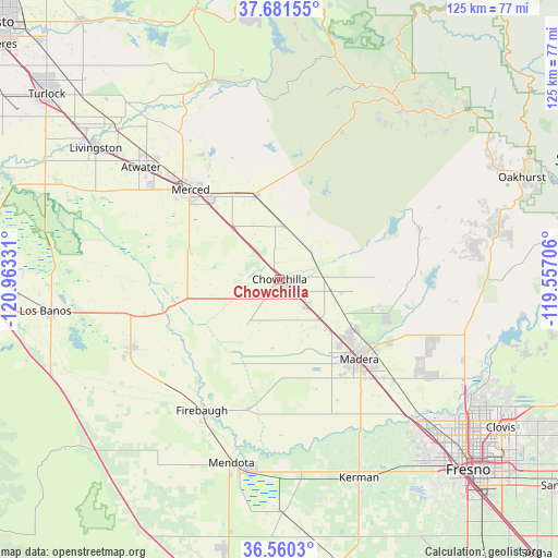
Chowchilla GPS coordinates[2]
37° 7' 22.8" North, 120° 15' 36.648" West
| Map corner | latitude | longitude |
|---|---|---|
| Upper-left | 37.68155°, | -120.96331° |
| Center: | 37.123°, | -120.26018° |
| Lower-right: | 36.5603°, | -119.55706° |
| Map W x H: | 124.7×124.7 km | = 77.5×77.5mi |
| max Lat: | 71.29058° ⇑65.6% North |
| Chowchilla: | 37.123° |
| min Lat: | ⇓34.4% South 19.06759° |
| min Long | Chowchilla | max Long |
| -171.73463° | -120.26018° | -66.98998° |
| W 6.9%⇐ | ⇒93.1% E |
Elevation
Elevation of Chowchilla is 75 m = 246 ft, and this is 219.8 m = 721 ft below average elevation for this country.
| Max E: |
3189 m = 10463 ft | 74.4% |
| Avg. | 294.8 m = 967 ft | |
| Chowchilla | 75 m = 246 ft | |
Min E: |
-60 m = -197 ft | 25.6% |
See also: United States elevation on elevation.city.
Geographical zone
Chowchilla is located in North temperate zone (between Tropic of Cancer and the Arctic Circle). Distance of this Northern Tropic circle is 1521.8 km =945.6 mi to South.| Distance of | km | miles | from Chowchilla |
|---|---|---|---|
| North Pole | 5879.4 | 3653.3 | to North |
| Arctic Circle | 3273.5 | 2034.1 | to North |
| Tropic Cancer | 1521.8 | 945.6 | to South |
| Equator | 4127.7 | 2564.8 | to South |


Nearby cities:
15 places around Chowchilla: (largest is in red/bold)
• Atwater
39.7 km =24.7 mi,  308°
308°
• Biola
41.7 km =25.9 mi,  148°
148°
• Bonadelle Ranchos-Madera Ranchos
37.5 km =23.3 mi,  114°
114°
• Catheys Valley
37.3 km =23.2 mi,  22°
22°
• Dos Palos
35.9 km =22.3 mi,  244°
244°
• Fairmead
7.9 km =4.9 mi,  131°
131°
• Firebaugh
34.1 km =21.2 mi,  210°
210°
• Le Grand
11.8 km =7.3 mi,  5°
5°
• Madera
25.2 km =15.7 mi,  135°
135°
• Madera Acres
20.7 km =12.9 mi,  123°
123°
• Merced
28 km =17.4 mi,  315°
315°
• Parksdale
28.7 km =17.8 mi, 132°
• Parkwood
29 km =18 mi, 138°
• Planada
19.4 km =12.1 mi,  344°
344°
• South Dos Palos
39.1 km =24.3 mi, 243°
Sources, notices
• [Note1] Compared only with cities in United States existing in our database
• [Src1] Map data: © OpenStreetMap contributors (CC-BY-SA)
• [Src2] Other city data from geonames.org with taken over terms of usage.
• [Src3] Geographical zone / Annual Mean Temperature by Robert A. Rohde @ Wikipedia
