Los Altos Hills geodata
Los Altos Hills (California) is a populated place; located in United States in America/Los_Angeles (GMT-7) time zone. With population of 8,419 people, there are 5066 cities with bigger population in this country. Compared to other cities in United States, 64.5% of cities are located further ↑North; 95.5% of cities are located further →East and 73.9% of cities have higher elevation than Los Altos Hills. Note1


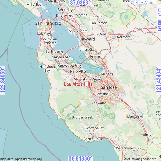
Los Altos Hills GPS coordinates[2]
37° 22' 46.776" North, 122° 8' 14.856" West
| Map corner | latitude | longitude |
|---|---|---|
| Upper-left | 37.9363°, | -122.84059° |
| Center: | 37.37966°, | -122.13746° |
| Lower-right: | 36.81886°, | -121.43434° |
| Map W x H: | 124.2×124.2 km | = 77.2×77.2mi |
| max Lat: | 71.29058° ⇑64.5% North |
| Los Altos Hills: | 37.37966° |
| min Lat: | ⇓35.5% South 19.06759° |
| min Long | Los Altos Hills | max Long |
| -171.73463° | -122.13746° | -66.98998° |
| W 4.5%⇐ | ⇒95.5% E |
Elevation
Elevation of Los Altos Hills is 78 m = 256 ft, and this is 216.8 m = 711 ft below average elevation for this country.
| Max E: |
3189 m = 10463 ft | 73.9% |
| Avg. | 294.8 m = 967 ft | |
| Los Altos Hills | 78 m = 256 ft | |
Min E: |
-60 m = -197 ft | 26.1% |
See also: United States elevation on elevation.city.
Geographical zone
Los Altos Hills is located in North temperate zone (between Tropic of Cancer and the Arctic Circle). Distance of this Northern Tropic circle is 1550.3 km =963.3 mi to South.| Distance of | km | miles | from Los Altos Hills |
|---|---|---|---|
| North Pole | 5850.8 | 3635.5 | to North |
| Arctic Circle | 3244.9 | 2016.3 | to North |
| Tropic Cancer | 1550.3 | 963.3 | to South |
| Equator | 4156.2 | 2582.5 | to South |


Nearby cities:
15 places around Los Altos Hills: (largest is in red/bold)
• Atherton
10.5 km =6.5 mi,  329°
329°
• Cupertino
11.2 km =7 mi,  124°
124°
• East Palo Alto
9.9 km =6.2 mi,  358°
358°
• Ladera
5.8 km =3.6 mi,  292°
292°
• Los Altos
2.2 km =1.4 mi,  73°
73°
• Loyola
4.5 km =2.8 mi,  133°
133°
• Menlo Park
9.1 km =5.7 mi, 334°
• Mountain View
4.8 km =3 mi,  81°
81°
• North Fair Oaks
11.8 km =7.3 mi, 333°
• Palo Alto
6.9 km =4.3 mi, 355°
• Portola Valley
8.7 km =5.4 mi,  273°
273°
• Stanford
5.6 km =3.5 mi, 332°
• Sunnyvale
9 km =5.6 mi,  97°
97°
• West Menlo Park
8.3 km =5.2 mi,  315°
315°
• Woodside
11.7 km =7.3 mi,  298°
298°
Sources, notices
• [Note1] Compared only with cities in United States existing in our database
• [Src1] Map data: © OpenStreetMap contributors (CC-BY-SA)
• [Src2] Other city data from geonames.org with taken over terms of usage.
• [Src3] Geographical zone / Annual Mean Temperature by Robert A. Rohde @ Wikipedia
