Sunnyvale geodata
Sunnyvale (California) is a populated place; located in United States in America/Los_Angeles (GMT-7) time zone. With population of 151,754 people, there are 190 cities with bigger population in this country. Compared to other cities in United States, 64.5% of cities are located further ↑North; 95.2% of cities are located further →East and 82.3% of cities have higher elevation than Sunnyvale. Note1


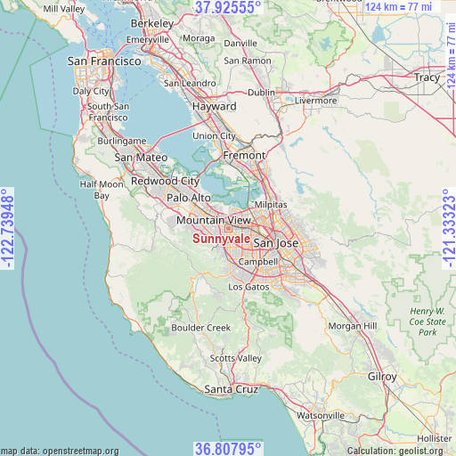
Sunnyvale GPS coordinates[2]
37° 22' 7.788" North, 122° 2' 10.86" West
| Map corner | latitude | longitude |
|---|---|---|
| Upper-left | 37.92555°, | -122.73948° |
| Center: | 37.36883°, | -122.03635° |
| Lower-right: | 36.80795°, | -121.33323° |
| Map W x H: | 124.3×124.3 km | = 77.2×77.2mi |
| max Lat: | 71.29058° ⇑64.5% North |
| Sunnyvale: | 37.36883° |
| min Lat: | ⇓35.5% South 19.06759° |
| min Long | Sunnyvale | max Long |
| -171.73463° | -122.03635° | -66.98998° |
| W 4.8%⇐ | ⇒95.2% E |
Elevation
Elevation of Sunnyvale is 37 m = 121 ft, and this is 257.8 m = 846 ft below average elevation for this country.
| Max E: |
3189 m = 10463 ft | 82.3% |
| Avg. | 294.8 m = 967 ft | |
| Sunnyvale | 37 m = 121 ft | |
Min E: |
-60 m = -197 ft | 17.7% |
See also: Sunnyvale elevation on elevation.city.
Geographical zone
Sunnyvale is located in North temperate zone (between Tropic of Cancer and the Arctic Circle). Distance of this Northern Tropic circle is 1549.1 km =962.6 mi to South.| Distance of | km | miles | from Sunnyvale |
|---|---|---|---|
| North Pole | 5852 | 3636.3 | to North |
| Arctic Circle | 3246.1 | 2017 | to North |
| Tropic Cancer | 1549.1 | 962.6 | to South |
| Equator | 4155 | 2581.8 | to South |


Nearby cities:
15 places around Sunnyvale: (largest is in red/bold)
• Buena Vista
11.8 km =7.3 mi,  116°
116°
• Burbank
10.6 km =6.6 mi, 118°
• Campbell
11.9 km =7.4 mi,  139°
139°
• Cupertino
5.1 km =3.2 mi,  175°
175°
• Fruitdale
11.2 km =7 mi,  125°
125°
• Los Altos
7.1 km =4.4 mi,  284°
284°
• Los Altos Hills
9 km =5.6 mi, 277°
• Loyola
6 km =3.7 mi,  251°
251°
• Milpitas
13.2 km =8.2 mi,  60°
60°
• Mountain View
4.6 km =2.9 mi,  294°
294°
• Palo Alto
12.4 km =7.7 mi,  310°
310°
• San Jose
12.9 km =8 mi,  104°
104°
• Santa Clara
7.4 km =4.6 mi, 102°
• Saratoga
11.7 km =7.3 mi,  174°
174°
• Stanford
13 km =8.1 mi,  298°
298°
Sources, notices
• [Note1] Compared only with cities in United States existing in our database
• [Src1] Map data: © OpenStreetMap contributors (CC-BY-SA)
• [Src2] Other city data from geonames.org with taken over terms of usage.
• [Src3] Geographical zone / Annual Mean Temperature by Robert A. Rohde @ Wikipedia
