Loyola geodata
Loyola (California) is a populated place; located in United States in America/Los_Angeles (GMT-7) time zone. With population of 3,261 people, there are 9208 cities with bigger population in this country. Compared to other cities in United States, 64.6% of cities are located further ↑North; 95.3% of cities are located further →East and 74% of cities have higher elevation than Loyola. Note1


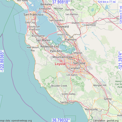
Loyola GPS coordinates[2]
37° 21' 4.788" North, 122° 6' 1.872" West
| Map corner | latitude | longitude |
|---|---|---|
| Upper-left | 37.90818°, | -122.80365° |
| Center: | 37.35133°, | -122.10052° |
| Lower-right: | 36.79032°, | -121.3974° |
| Map W x H: | 124.3×124.3 km | = 77.2×77.2mi |
| max Lat: | 71.29058° ⇑64.6% North |
| Loyola: | 37.35133° |
| min Lat: | ⇓35.4% South 19.06759° |
| min Long | Loyola | max Long |
| -171.73463° | -122.10052° | -66.98998° |
| W 4.7%⇐ | ⇒95.3% E |
Elevation
Elevation of Loyola is 77 m = 253 ft, and this is 217.8 m = 715 ft below average elevation for this country.
| Max E: |
3189 m = 10463 ft | 74% |
| Avg. | 294.8 m = 967 ft | |
| Loyola | 77 m = 253 ft | |
Min E: |
-60 m = -197 ft | 26% |
See also: United States elevation on elevation.city.
Geographical zone
Loyola is located in North temperate zone (between Tropic of Cancer and the Arctic Circle). Distance of this Northern Tropic circle is 1547.2 km =961.4 mi to South.| Distance of | km | miles | from Loyola |
|---|---|---|---|
| North Pole | 5854 | 3637.5 | to North |
| Arctic Circle | 3248.1 | 2018.3 | to North |
| Tropic Cancer | 1547.2 | 961.4 | to South |
| Equator | 4153.1 | 2580.6 | to South |


Nearby cities:
15 places around Loyola: (largest is in red/bold)
• Atherton
14.9 km =9.3 mi,  324°
324°
• Cupertino
6.8 km =4.2 mi,  117°
117°
• East Palo Alto
13.5 km =8.4 mi,  344°
344°
• Ladera
10.2 km =6.3 mi,  302°
302°
• Los Altos
4 km =2.5 mi, 342°
• Los Altos Hills
4.5 km =2.8 mi,  313°
313°
• Menlo Park
13.5 km =8.4 mi,  327°
327°
• Mountain View
4.1 km =2.5 mi,  20°
20°
• Palo Alto
10.7 km =6.6 mi, 339°
• Portola Valley
12.5 km =7.8 mi,  287°
287°
• Santa Clara
12.8 km =8 mi,  88°
88°
• Saratoga
11.9 km =7.4 mi,  144°
144°
• Stanford
10 km =6.2 mi, 324°
• Sunnyvale
6 km =3.7 mi,  71°
71°
• West Menlo Park
12.9 km =8 mi, 315°
Sources, notices
• [Note1] Compared only with cities in United States existing in our database
• [Src1] Map data: © OpenStreetMap contributors (CC-BY-SA)
• [Src2] Other city data from geonames.org with taken over terms of usage.
• [Src3] Geographical zone / Annual Mean Temperature by Robert A. Rohde @ Wikipedia
