Cupertino geodata
Cupertino (California) is a populated place; located in United States in America/Los_Angeles (GMT-7) time zone. With population of 60,572 people, there are 733 cities with bigger population in this country. Compared to other cities in United States, 64.8% of cities are located further ↑North; 95.2% of cities are located further →East and 74.9% of cities have higher elevation than Cupertino. Note1


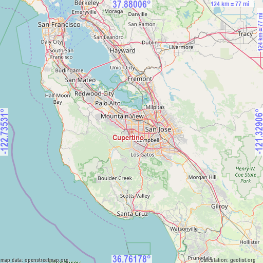
Cupertino GPS coordinates[2]
37° 19' 22.8" North, 122° 1' 55.848" West
| Map corner | latitude | longitude |
|---|---|---|
| Upper-left | 37.88006°, | -122.73531° |
| Center: | 37.323°, | -122.03218° |
| Lower-right: | 36.76178°, | -121.32906° |
| Map W x H: | 124.3×124.3 km | = 77.2×77.2mi |
| max Lat: | 71.29058° ⇑64.8% North |
| Cupertino: | 37.323° |
| min Lat: | ⇓35.2% South 19.06759° |
| min Long | Cupertino | max Long |
| -171.73463° | -122.03218° | -66.98998° |
| W 4.8%⇐ | ⇒95.2% E |
Elevation
Elevation of Cupertino is 72 m = 236 ft, and this is 222.8 m = 731 ft below average elevation for this country.
| Max E: |
3189 m = 10463 ft | 74.9% |
| Avg. | 294.8 m = 967 ft | |
| Cupertino | 72 m = 236 ft | |
Min E: |
-60 m = -197 ft | 25.1% |
See also: Cupertino elevation on elevation.city.
Geographical zone
Cupertino is located in North temperate zone (between Tropic of Cancer and the Arctic Circle). Distance of this Northern Tropic circle is 1544 km =959.4 mi to South.| Distance of | km | miles | from Cupertino |
|---|---|---|---|
| North Pole | 5857.1 | 3639.4 | to North |
| Arctic Circle | 3251.2 | 2020.2 | to North |
| Tropic Cancer | 1544 | 959.4 | to South |
| Equator | 4149.9 | 2578.6 | to South |


Nearby cities:
15 places around Cupertino: (largest is in red/bold)
• Buena Vista
10.2 km =6.3 mi,  91°
91°
• Burbank
8.9 km =5.5 mi, 89°
• Cambrian Park
11.6 km =7.2 mi,  129°
129°
• Campbell
8.3 km =5.2 mi,  118°
118°
• Fruitdale
8.9 km =5.5 mi,  98°
98°
• Los Altos
10 km =6.2 mi,  313°
313°
• Los Altos Hills
11.2 km =7 mi,  304°
304°
• Los Gatos
11.9 km =7.4 mi,  154°
154°
• Loyola
6.8 km =4.2 mi, 297°
• Monte Sereno
10.3 km =6.4 mi,  159°
159°
• Mountain View
8.4 km =5.2 mi,  326°
326°
• San Jose
12.3 km =7.6 mi,  81°
81°
• Santa Clara
7.6 km =4.7 mi,  63°
63°
• Saratoga
6.6 km =4.1 mi,  172°
172°
• Sunnyvale
5.1 km =3.2 mi,  355°
355°
Sources, notices
• [Note1] Compared only with cities in United States existing in our database
• [Src1] Map data: © OpenStreetMap contributors (CC-BY-SA)
• [Src2] Other city data from geonames.org with taken over terms of usage.
• [Src3] Geographical zone / Annual Mean Temperature by Robert A. Rohde @ Wikipedia
