Tracy geodata
Tracy (California) is a populated place; located in United States in America/Los_Angeles (GMT-7) time zone. With population of 87,075 people, there are 437 cities with bigger population in this country. Compared to other cities in United States, 63% of cities are located further ↑North; 94.3% of cities are located further →East and 89.5% of cities have higher elevation than Tracy. Note1


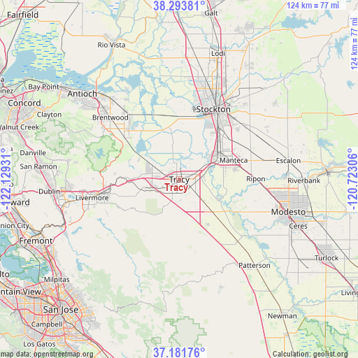
Tracy GPS coordinates[2]
37° 44' 23.532" North, 121° 25' 34.248" West
| Map corner | latitude | longitude |
|---|---|---|
| Upper-left | 38.29381°, | -122.12931° |
| Center: | 37.73987°, | -121.42618° |
| Lower-right: | 37.18176°, | -120.72306° |
| Map W x H: | 123.6×123.6 km | = 76.8×76.8mi |
| max Lat: | 71.29058° ⇑63% North |
| Tracy: | 37.73987° |
| min Lat: | ⇓37% South 19.06759° |
| min Long | Tracy | max Long |
| -171.73463° | -121.42618° | -66.98998° |
| W 5.7%⇐ | ⇒94.3% E |
Elevation
Elevation of Tracy is 17 m = 56 ft, and this is 277.8 m = 911 ft below average elevation for this country.
| Max E: |
3189 m = 10463 ft | 89.5% |
| Avg. | 294.8 m = 967 ft | |
| Tracy | 17 m = 56 ft | |
Min E: |
-60 m = -197 ft | 10.5% |
See also: Tracy elevation on elevation.city.
Geographical zone
Tracy is located in North temperate zone (between Tropic of Cancer and the Arctic Circle). Distance of this Northern Tropic circle is 1590.4 km =988.2 mi to South.| Distance of | km | miles | from Tracy |
|---|---|---|---|
| North Pole | 5810.8 | 3610.7 | to North |
| Arctic Circle | 3204.9 | 1991.4 | to North |
| Tropic Cancer | 1590.4 | 988.2 | to South |
| Equator | 4196.3 | 2607.5 | to South |


Nearby cities:
15 places around Tracy: (largest is in red/bold)
• August
30.2 km =18.8 mi,  28°
28°
• Byron
23.4 km =14.5 mi,  307°
307°
• Country Club
26.5 km =16.5 mi,  16°
16°
• Discovery Bay
24.2 km =15 mi,  320°
320°
• French Camp
21 km =13 mi,  40°
40°
• Garden Acres
30.3 km =18.8 mi, 34°
• Grayson
29.2 km =18.1 mi,  132°
132°
• Kennedy
26 km =16.2 mi, 35°
• Lathrop
16 km =9.9 mi,  54°
54°
• Manteca
19.5 km =12.1 mi,  70°
70°
• Mountain House
11.3 km =7 mi,  295°
295°
• Ripon
26.5 km =16.5 mi,  89°
89°
• Stockton
27 km =16.8 mi, 26°
• Taft Mosswood
23.1 km =14.4 mi, 32°
• Westley
29.1 km =18.1 mi,  136°
136°
Sources, notices
• [Note1] Compared only with cities in United States existing in our database
• [Src1] Map data: © OpenStreetMap contributors (CC-BY-SA)
• [Src2] Other city data from geonames.org with taken over terms of usage.
• [Src3] Geographical zone / Annual Mean Temperature by Robert A. Rohde @ Wikipedia
