Sunol geodata
Sunol (California) is a populated place; located in United States in America/Los_Angeles (GMT-7) time zone. With population of 913 people, there are 16907 cities with bigger population in this country. Compared to other cities in United States, 63.7% of cities are located further ↑North; 94.8% of cities are located further →East and 73.7% of cities have higher elevation than Sunol. Note1


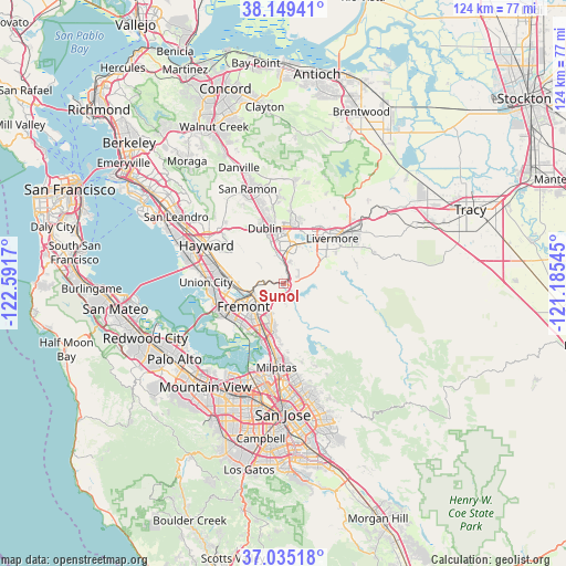
Sunol GPS coordinates[2]
37° 35' 39.768" North, 121° 53' 18.852" West
| Map corner | latitude | longitude |
|---|---|---|
| Upper-left | 38.14941°, | -122.5917° |
| Center: | 37.59438°, | -121.88857° |
| Lower-right: | 37.03518°, | -121.18545° |
| Map W x H: | 123.9×123.9 km | = 77×77mi |
| max Lat: | 71.29058° ⇑63.7% North |
| Sunol: | 37.59438° |
| min Lat: | ⇓36.3% South 19.06759° |
| min Long | Sunol | max Long |
| -171.73463° | -121.88857° | -66.98998° |
| W 5.2%⇐ | ⇒94.8% E |
Elevation
Elevation of Sunol is 79 m = 259 ft, and this is 215.8 m = 708 ft below average elevation for this country.
| Max E: |
3189 m = 10463 ft | 73.7% |
| Avg. | 294.8 m = 967 ft | |
| Sunol | 79 m = 259 ft | |
Min E: |
-60 m = -197 ft | 26.3% |
See also: United States elevation on elevation.city.
Geographical zone
Sunol is located in North temperate zone (between Tropic of Cancer and the Arctic Circle). Distance of this Northern Tropic circle is 1574.2 km =978.2 mi to South.| Distance of | km | miles | from Sunol |
|---|---|---|---|
| North Pole | 5827 | 3620.7 | to North |
| Arctic Circle | 3221.1 | 2001.5 | to North |
| Tropic Cancer | 1574.2 | 978.2 | to South |
| Equator | 4180.1 | 2597.4 | to South |


Nearby cities:
15 places around Sunol: (largest is in red/bold)
• Ashland
22.8 km =14.2 mi,  299°
299°
• Castro Valley
20.6 km =12.8 mi, 302°
• Cherryland
21.1 km =13.1 mi, 296°
• Dublin
12.7 km =7.9 mi,  340°
340°
• East Foothills
24.5 km =15.2 mi,  165°
165°
• Fairview
16.7 km =10.4 mi, 304°
• Fremont
10.2 km =6.3 mi,  239°
239°
• Hayward
18.8 km =11.7 mi, 296°
• Livermore
14.4 km =8.9 mi,  47°
47°
• Milpitas
18.5 km =11.5 mi,  184°
184°
• Newark
15.2 km =9.4 mi, 241°
• Pleasanton
7.7 km =4.8 mi,  9°
9°
• San Lorenzo
22.9 km =14.2 mi,  294°
294°
• San Ramon
22.1 km =13.7 mi, 339°
• Union City
11.5 km =7.1 mi,  270°
270°
Sources, notices
• [Note1] Compared only with cities in United States existing in our database
• [Src1] Map data: © OpenStreetMap contributors (CC-BY-SA)
• [Src2] Other city data from geonames.org with taken over terms of usage.
• [Src3] Geographical zone / Annual Mean Temperature by Robert A. Rohde @ Wikipedia
