Milpitas geodata
Milpitas (California) is a populated place; located in United States in America/Los_Angeles (GMT-7) time zone. With population of 77,604 people, there are 516 cities with bigger population in this country. Compared to other cities in United States, 64.3% of cities are located further ↑North; 94.8% of cities are located further →East and 98.1% of cities have higher elevation than Milpitas. Note1


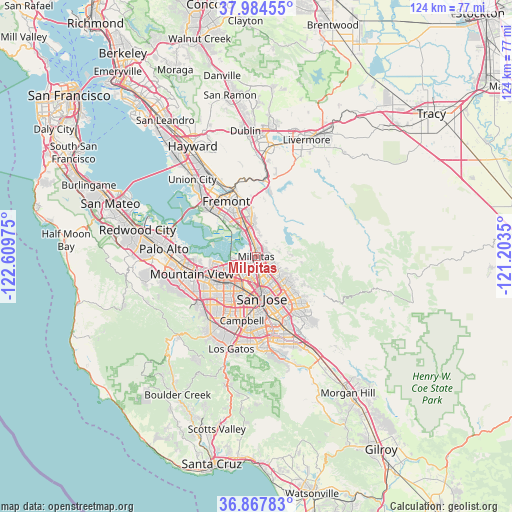
Milpitas GPS coordinates[2]
37° 25' 41.772" North, 121° 54' 23.832" West
| Map corner | latitude | longitude |
|---|---|---|
| Upper-left | 37.98455°, | -122.60975° |
| Center: | 37.42827°, | -121.90662° |
| Lower-right: | 36.86783°, | -121.2035° |
| Map W x H: | 124.2×124.2 km | = 77.2×77.2mi |
| max Lat: | 71.29058° ⇑64.3% North |
| Milpitas: | 37.42827° |
| min Lat: | ⇓35.7% South 19.06759° |
| min Long | Milpitas | max Long |
| -171.73463° | -121.90662° | -66.98998° |
| W 5.2%⇐ | ⇒94.8% E |
Elevation
Elevation of Milpitas is 5 m = 16 ft, and this is 289.8 m = 951 ft below average elevation for this country.
| Max E: |
3189 m = 10463 ft | 98.1% |
| Avg. | 294.8 m = 967 ft | |
| Milpitas | 5 m = 16 ft | |
Min E: |
-60 m = -197 ft | 1.9% |
See also: Milpitas elevation on elevation.city.
Geographical zone
Milpitas is located in North temperate zone (between Tropic of Cancer and the Arctic Circle). Distance of this Northern Tropic circle is 1555.7 km =966.7 mi to South.| Distance of | km | miles | from Milpitas |
|---|---|---|---|
| North Pole | 5845.4 | 3632.2 | to North |
| Arctic Circle | 3239.5 | 2012.9 | to North |
| Tropic Cancer | 1555.7 | 966.7 | to South |
| Equator | 4161.6 | 2585.9 | to South |


Nearby cities:
15 places around Milpitas: (largest is in red/bold)
• Alum Rock
9.9 km =6.2 mi,  134°
134°
• Buena Vista
11.9 km =7.4 mi,  184°
184°
• Burbank
11.9 km =7.4 mi,  190°
190°
• Campbell
16.1 km =10 mi, 193°
• Cupertino
16.1 km =10 mi,  223°
223°
• East Foothills
9.5 km =5.9 mi,  123°
123°
• Fremont
15.2 km =9.4 mi,  331°
331°
• Fruitdale
13.3 km =8.3 mi, 190°
• Mountain View
16.3 km =10.1 mi,  253°
253°
• Newark
16.3 km =10.1 mi,  313°
313°
• San Jose
9.9 km =6.2 mi,  174°
174°
• Santa Clara
9.3 km =5.8 mi,  207°
207°
• Seven Trees
16.9 km =10.5 mi,  159°
159°
• Sunnyvale
13.2 km =8.2 mi,  240°
240°
• Sunol
18.5 km =11.5 mi,  4°
4°
Sources, notices
• [Note1] Compared only with cities in United States existing in our database
• [Src1] Map data: © OpenStreetMap contributors (CC-BY-SA)
• [Src2] Other city data from geonames.org with taken over terms of usage.
• [Src3] Geographical zone / Annual Mean Temperature by Robert A. Rohde @ Wikipedia
