Red Bluff geodata
Red Bluff (California) is a seat of a second-order administrative division; located in United States in America/Los_Angeles (GMT-7) time zone. With population of 14,131 people, there are 3405 cities with bigger population in this country. Compared to other cities in United States, 55.3% of cities are located further ↓South; 95.8% of cities are located further →East and 71.1% of cities have higher elevation than Red Bluff. Note1


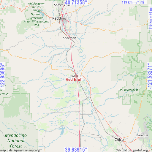
Red Bluff GPS coordinates[2]
40° 10' 42.564" North, 122° 14' 8.988" West
| Map corner | latitude | longitude |
|---|---|---|
| Upper-left | 40.71358°, | -122.93896° |
| Center: | 40.17849°, | -122.23583° |
| Lower-right: | 39.63915°, | -121.53271° |
| Map W x H: | 119.5×119.5 km | = 74.3×74.3mi |
| max Lat: | 71.29058° ⇑44.7% North |
| Red Bluff: | 40.17849° |
| min Lat: | ⇓55.3% South 19.06759° |
| min Long | Red Bluff | max Long |
| -171.73463° | -122.23583° | -66.98998° |
| W 4.2%⇐ | ⇒95.8% E |
Elevation
Elevation of Red Bluff is 94 m = 308 ft, and this is 200.8 m = 659 ft below average elevation for this country.
| Max E: |
3189 m = 10463 ft | 71.1% |
| Avg. | 294.8 m = 967 ft | |
| Red Bluff | 94 m = 308 ft | |
Min E: |
-60 m = -197 ft | 28.9% |
See also: United States elevation on elevation.city.
Geographical zone
Red Bluff is located in North temperate zone (between Tropic of Cancer and the Arctic Circle). Distance of this Northern Tropic circle is 1861.5 km =1156.7 mi to South.| Distance of | km | miles | from Red Bluff |
|---|---|---|---|
| North Pole | 5539.6 | 3442.1 | to North |
| Arctic Circle | 2933.7 | 1822.9 | to North |
| Tropic Cancer | 1861.5 | 1156.7 | to South |
| Equator | 4467.4 | 2775.9 | to South |


Nearby cities:
15 places around Red Bluff: (largest is in red/bold)
• Anderson
30.4 km =18.9 mi,  350°
350°
• Bella Vista
51.4 km =31.9 mi,  0°
0°
• Bend
8.8 km =5.5 mi,  15°
15°
• Cohasset
51.4 km =31.9 mi,  123°
123°
• Corning
28.3 km =17.6 mi,  170°
170°
• Cottonwood
23.4 km =14.5 mi, 350°
• Gerber
15.4 km =9.6 mi,  151°
151°
• Los Molinos
20.9 km =13 mi, 146°
• Millville
41.6 km =25.8 mi,  7°
7°
• Orland
48.1 km =29.9 mi,  175°
175°
• Palo Cedro
42.8 km =26.6 mi,  359°
359°
• Rancho Tehama Reserve
22.9 km =14.2 mi,  217°
217°
• Redding
47.3 km =29.4 mi,  343°
343°
• Shasta
51.6 km =32.1 mi, 335°
• Shingletown
45.6 km =28.3 mi,  40°
40°
Sources, notices
• [Note1] Compared only with cities in United States existing in our database
• [Src1] Map data: © OpenStreetMap contributors (CC-BY-SA)
• [Src2] Other city data from geonames.org with taken over terms of usage.
• [Src3] Geographical zone / Annual Mean Temperature by Robert A. Rohde @ Wikipedia
