Palmdale geodata
Palmdale (California) is a populated place; located in United States in America/Los_Angeles (GMT-7) time zone. With population of 158,351 people, there are 179 cities with bigger population in this country. Compared to other cities in United States, 77.4% of cities are located further ↑North; 91.1% of cities are located further →East and 92.2% of cities have lower elevation than Palmdale. Note1


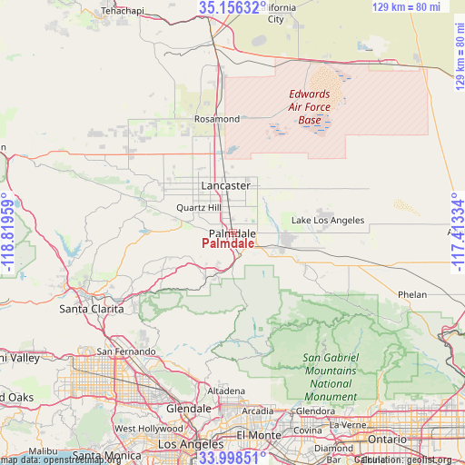
Palmdale GPS coordinates[2]
34° 34' 45.948" North, 118° 6' 59.256" West
| Map corner | latitude | longitude |
|---|---|---|
| Upper-left | 35.15632°, | -118.81959° |
| Center: | 34.57943°, | -118.11646° |
| Lower-right: | 33.99851°, | -117.41334° |
| Map W x H: | 128.7×128.7 km | = 80×80mi |
| max Lat: | 71.29058° ⇑77.4% North |
| Palmdale: | 34.57943° |
| min Lat: | ⇓22.6% South 19.06759° |
| min Long | Palmdale | max Long |
| -171.73463° | -118.11646° | -66.98998° |
| W 8.9%⇐ | ⇒91.1% E |
Elevation
Elevation of Palmdale is 815 m = 2674 ft, and this is 520.2 m = 1707 ft above average elevation for this country.
| Max E: |
3189 m = 10463 ft | 7.8% |
| Palmdale | 815 m 2674 ft | |
| Avg. | 294.8 m = 967 ft | |
Min E: |
-60 m = -197 ft | 92.2% |
See also: Palmdale elevation on elevation.city.
Geographical zone
Palmdale is located in North temperate zone (between Tropic of Cancer and the Arctic Circle). Distance of this Northern Tropic circle is 1239 km =769.9 mi to South.| Distance of | km | miles | from Palmdale |
|---|---|---|---|
| North Pole | 6162.2 | 3829 | to North |
| Arctic Circle | 3556.3 | 2209.8 | to North |
| Tropic Cancer | 1239 | 769.9 | to South |
| Equator | 3844.9 | 2389.1 | to South |


Nearby cities:
15 places around Palmdale: (largest is in red/bold)
• Acton
14.2 km =8.8 mi,  211°
211°
• Agua Dulce
21.3 km =13.2 mi,  244°
244°
• Desert View Highlands
3.5 km =2.2 mi,  290°
290°
• Green Valley
27.6 km =17.1 mi,  279°
279°
• Lake Hughes
32 km =19.9 mi, 289°
• Lake Los Angeles
26.6 km =16.5 mi,  82°
82°
• Lancaster
13.3 km =8.3 mi,  351°
351°
• Leona Valley
16.3 km =10.1 mi, 285°
• Littlerock
13.8 km =8.6 mi,  118°
118°
• Quartz Hill
11.8 km =7.3 mi,  308°
308°
• Rosamond
31.9 km =19.8 mi, 352°
• Sun Village
14.8 km =9.2 mi,  98°
98°
• Sunland
38.7 km =24 mi, 206°
• Tujunga
39.7 km =24.7 mi,  203°
203°
• Vincent
8.8 km =5.5 mi,  180°
180°
Sources, notices
• [Note1] Compared only with cities in United States existing in our database
• [Src1] Map data: © OpenStreetMap contributors (CC-BY-SA)
• [Src2] Other city data from geonames.org with taken over terms of usage.
• [Src3] Geographical zone / Annual Mean Temperature by Robert A. Rohde @ Wikipedia
