Lancaster geodata
Lancaster (California) is a populated place; located in United States in America/Los_Angeles (GMT-7) time zone. With population of 161,103 people, there are 176 cities with bigger population in this country. Compared to other cities in United States, 76.8% of cities are located further ↑North; 91.1% of cities are located further →East and 91.1% of cities have lower elevation than Lancaster. Note1


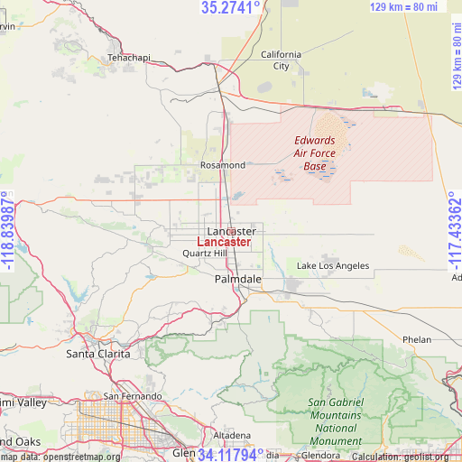
Lancaster GPS coordinates[2]
34° 41' 52.944" North, 118° 8' 12.264" West
| Map corner | latitude | longitude |
|---|---|---|
| Upper-left | 35.2741°, | -118.83987° |
| Center: | 34.69804°, | -118.13674° |
| Lower-right: | 34.11794°, | -117.43362° |
| Map W x H: | 128.6×128.6 km | = 79.9×79.9mi |
| max Lat: | 71.29058° ⇑76.8% North |
| Lancaster: | 34.69804° |
| min Lat: | ⇓23.2% South 19.06759° |
| min Long | Lancaster | max Long |
| -171.73463° | -118.13674° | -66.98998° |
| W 8.9%⇐ | ⇒91.1% E |
Elevation
Elevation of Lancaster is 718 m = 2356 ft, and this is 423.2 m = 1388 ft above average elevation for this country.
| Max E: |
3189 m = 10463 ft | 8.9% |
| Lancaster | 718 m 2356 ft | |
| Avg. | 294.8 m = 967 ft | |
Min E: |
-60 m = -197 ft | 91.1% |
See also: Lancaster elevation on elevation.city.
Geographical zone
Lancaster is located in North temperate zone (between Tropic of Cancer and the Arctic Circle). Distance of this Northern Tropic circle is 1252.1 km =778 mi to South.| Distance of | km | miles | from Lancaster |
|---|---|---|---|
| North Pole | 6149 | 3820.8 | to North |
| Arctic Circle | 3543.1 | 2201.6 | to North |
| Tropic Cancer | 1252.1 | 778 | to South |
| Equator | 3858.1 | 2397.3 | to South |


Nearby cities:
15 places around Lancaster: (largest is in red/bold)
• Acton
25.9 km =16.1 mi,  192°
192°
• Agua Dulce
28.3 km =17.6 mi,  217°
217°
• Desert View Highlands
12 km =7.5 mi, 186°
• Edwards Air Force Base
30.5 km =19 mi,  37°
37°
• Green Valley
26.7 km =16.6 mi,  251°
251°
• Lake Hughes
28.3 km =17.6 mi,  265°
265°
• Lake Los Angeles
29.8 km =18.5 mi,  108°
108°
• Leona Valley
16.4 km =10.2 mi,  237°
237°
• Littlerock
24.2 km =15 mi,  144°
144°
• Mojave
39.6 km =24.6 mi,  355°
355°
• Palmdale
13.3 km =8.3 mi,  171°
171°
• Quartz Hill
9.5 km =5.9 mi,  231°
231°
• Rosamond
18.6 km =11.6 mi,  352°
352°
• Sun Village
22.5 km =14 mi,  133°
133°
• Vincent
22 km =13.7 mi,  175°
175°
Sources, notices
• [Note1] Compared only with cities in United States existing in our database
• [Src1] Map data: © OpenStreetMap contributors (CC-BY-SA)
• [Src2] Other city data from geonames.org with taken over terms of usage.
• [Src3] Geographical zone / Annual Mean Temperature by Robert A. Rohde @ Wikipedia
