Leona Valley geodata
Leona Valley (California) is a populated place; located in United States in America/Los_Angeles (GMT-7) time zone. With population of 1,607 people, there are 13277 cities with bigger population in this country. Compared to other cities in United States, 77.2% of cities are located further ↑North; 91.3% of cities are located further →East and 93.2% of cities have lower elevation than Leona Valley. Note1


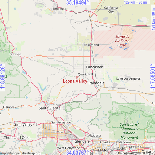
Leona Valley GPS coordinates[2]
34° 37' 5.952" North, 118° 17' 17.268" West
| Map corner | latitude | longitude |
|---|---|---|
| Upper-left | 35.19494°, | -118.99126° |
| Center: | 34.61832°, | -118.28813° |
| Lower-right: | 34.03767°, | -117.58501° |
| Map W x H: | 128.7×128.7 km | = 80×80mi |
| max Lat: | 71.29058° ⇑77.2% North |
| Leona Valley: | 34.61832° |
| min Lat: | ⇓22.8% South 19.06759° |
| min Long | Leona Valley | max Long |
| -171.73463° | -118.28813° | -66.98998° |
| W 8.7%⇐ | ⇒91.3% E |
Elevation
Elevation of Leona Valley is 963 m = 3159 ft, and this is 668.2 m = 2192 ft above average elevation for this country.
| Max E: |
3189 m = 10463 ft | 6.8% |
| Leona Valley | 963 m 3159 ft | |
| Avg. | 294.8 m = 967 ft | |
Min E: |
-60 m = -197 ft | 93.2% |
See also: United States elevation on elevation.city.
Geographical zone
Leona Valley is located in North temperate zone (between Tropic of Cancer and the Arctic Circle). Distance of this Northern Tropic circle is 1243.3 km =772.6 mi to South.| Distance of | km | miles | from Leona Valley |
|---|---|---|---|
| North Pole | 6157.9 | 3826.3 | to North |
| Arctic Circle | 3552 | 2207.1 | to North |
| Tropic Cancer | 1243.3 | 772.6 | to South |
| Equator | 3849.2 | 2391.8 | to South |


Nearby cities:
15 places around Leona Valley: (largest is in red/bold)
• Acton
18.5 km =11.5 mi,  153°
153°
• Agua Dulce
14 km =8.7 mi,  194°
194°
• Castaic
33.9 km =21.1 mi,  244°
244°
• Desert View Highlands
12.8 km =8 mi,  103°
103°
• Green Valley
11.5 km =7.1 mi,  271°
271°
• Lake Hughes
15.8 km =9.8 mi,  294°
294°
• Lancaster
16.4 km =10.2 mi,  57°
57°
• Littlerock
29.9 km =18.6 mi,  111°
111°
• Palmdale
16.3 km =10.1 mi, 105°
• Quartz Hill
7.1 km =4.4 mi, 64°
• Rosamond
29.6 km =18.4 mi,  22°
22°
• Santa Clarita
34.3 km =21.3 mi,  222°
222°
• Sun Village
31 km =19.3 mi, 102°
• Valencia
35.3 km =21.9 mi, 236°
• Vincent
20.5 km =12.7 mi,  129°
129°
Sources, notices
• [Note1] Compared only with cities in United States existing in our database
• [Src1] Map data: © OpenStreetMap contributors (CC-BY-SA)
• [Src2] Other city data from geonames.org with taken over terms of usage.
• [Src3] Geographical zone / Annual Mean Temperature by Robert A. Rohde @ Wikipedia
