Sonoma geodata
Sonoma (California) is a populated place; located in United States in America/Los_Angeles (GMT-7) time zone. With population of 11,037 people, there are 4169 cities with bigger population in this country. Compared to other cities in United States, 60% of cities are located further ↑North; 96.5% of cities are located further →East and 85.4% of cities have higher elevation than Sonoma. Note1


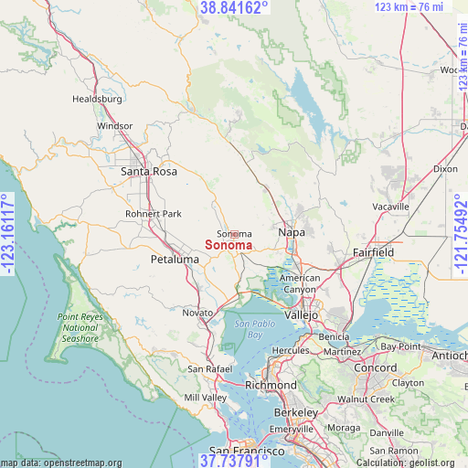
Sonoma GPS coordinates[2]
38° 17' 30.696" North, 122° 27' 28.944" West
| Map corner | latitude | longitude |
|---|---|---|
| Upper-left | 38.84162°, | -123.16117° |
| Center: | 38.29186°, | -122.45804° |
| Lower-right: | 37.73791°, | -121.75492° |
| Map W x H: | 122.7×122.7 km | = 76.2×76.2mi |
| max Lat: | 71.29058° ⇑60% North |
| Sonoma: | 38.29186° |
| min Lat: | ⇓40% South 19.06759° |
| min Long | Sonoma | max Long |
| -171.73463° | -122.45804° | -66.98998° |
| W 3.5%⇐ | ⇒96.5% E |
Elevation
Elevation of Sonoma is 27 m = 89 ft, and this is 267.8 m = 879 ft below average elevation for this country.
| Max E: |
3189 m = 10463 ft | 85.4% |
| Avg. | 294.8 m = 967 ft | |
| Sonoma | 27 m = 89 ft | |
Min E: |
-60 m = -197 ft | 14.6% |
See also: United States elevation on elevation.city.
Geographical zone
Sonoma is located in North temperate zone (between Tropic of Cancer and the Arctic Circle). Distance of this Northern Tropic circle is 1651.7 km =1026.3 mi to South.| Distance of | km | miles | from Sonoma |
|---|---|---|---|
| North Pole | 5749.4 | 3572.5 | to North |
| Arctic Circle | 3143.5 | 1953.3 | to North |
| Tropic Cancer | 1651.7 | 1026.3 | to South |
| Equator | 4257.7 | 2645.6 | to South |


Nearby cities:
15 places around Sonoma: (largest is in red/bold)
• American Canyon
21.6 km =13.4 mi,  127°
127°
• Black Point-Green Point
20.2 km =12.6 mi,  193°
193°
• Boyes Hot Springs
3.2 km =2 mi,  319°
319°
• Cotati
22.1 km =13.7 mi,  280°
280°
• El Verano
3 km =1.9 mi, 282°
• Eldridge
7.8 km =4.8 mi, 323°
• Fetters Hot Springs-Agua Caliente
4.1 km =2.5 mi, 322°
• Glen Ellen
9.9 km =6.2 mi, 324°
• Kenwood
15.6 km =9.7 mi,  330°
330°
• Napa
15.1 km =9.4 mi,  87°
87°
• Penngrove
18.2 km =11.3 mi,  272°
272°
• Petaluma
16.9 km =10.5 mi,  247°
247°
• Rohnert Park
21.9 km =13.6 mi, 284°
• Temelec
4.1 km =2.5 mi,  227°
227°
• Yountville
14.9 km =9.3 mi,  34°
34°
Sources, notices
• [Note1] Compared only with cities in United States existing in our database
• [Src1] Map data: © OpenStreetMap contributors (CC-BY-SA)
• [Src2] Other city data from geonames.org with taken over terms of usage.
• [Src3] Geographical zone / Annual Mean Temperature by Robert A. Rohde @ Wikipedia
