Pine Mountain Club geodata
Pine Mountain Club (California) is a populated place; located in United States in America/Los_Angeles (GMT-7) time zone. With population of 2,315 people, there are 11052 cities with bigger population in this country. Compared to other cities in United States, 76.2% of cities are located further ↑North; 92% of cities are located further →East and 98% of cities have lower elevation than Pine Mountain Club. Note1


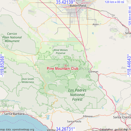
Pine Mountain Club GPS coordinates[2]
34° 50' 46.932" North, 119° 8' 58.38" West
| Map corner | latitude | longitude |
|---|---|---|
| Upper-left | 35.42139°, | -119.85268° |
| Center: | 34.84637°, | -119.14955° |
| Lower-right: | 34.26731°, | -118.44643° |
| Map W x H: | 128.3×128.3 km | = 79.7×79.7mi |
| max Lat: | 71.29058° ⇑76.2% North |
| Pine Mountain Club: | 34.84637° |
| min Lat: | ⇓23.8% South 19.06759° |
| min Long | Pine Mountain C | max Long |
| -171.73463° | -119.14955° | -66.98998° |
| W 8%⇐ | ⇒92% E |
Elevation
Elevation of Pine Mountain Club is 1714 m = 5623 ft, and this is 1419.2 m = 4656 ft above average elevation for this country.
| Max E: |
3189 m = 10463 ft | 2% |
| Pine Mountain Club | 1714 m 5623 ft | |
| Avg. | 294.8 m = 967 ft | |
Min E: |
-60 m = -197 ft | 98% |
See also: United States elevation on elevation.city.
Geographical zone
Pine Mountain Club is located in North temperate zone (between Tropic of Cancer and the Arctic Circle). Distance of this Northern Tropic circle is 1268.6 km =788.3 mi to South.| Distance of | km | miles | from Pine Mountain Club |
|---|---|---|---|
| North Pole | 6132.5 | 3810.6 | to North |
| Arctic Circle | 3526.6 | 2191.3 | to North |
| Tropic Cancer | 1268.6 | 788.3 | to South |
| Equator | 3874.6 | 2407.6 | to South |


Nearby cities:
15 places around Pine Mountain Club: (largest is in red/bold)
• Dustin Acres
46.9 km =29.1 mi,  332°
332°
• Ford City
44.2 km =27.5 mi,  320°
320°
• Frazier Park
18.9 km =11.7 mi,  97°
97°
• Greenfield
48.8 km =30.3 mi,  15°
15°
• Lake of the Woods
14.3 km =8.9 mi, 102°
• Lebec
26 km =16.2 mi,  91°
91°
• Maricopa
32.9 km =20.4 mi, 315°
• Meiners Oaks
46 km =28.6 mi,  194°
194°
• Mira Monte
47.5 km =29.5 mi,  195°
195°
• Ojai
45.1 km =28 mi, 190°
• South Taft
42.5 km =26.4 mi, 318°
• Taft
43.2 km =26.8 mi, 319°
• Taft Heights
43.5 km =27 mi, 317°
• Valley Acres
46.3 km =28.8 mi, 329°
• Weedpatch
48.5 km =30.1 mi,  26°
26°
Sources, notices
• [Note1] Compared only with cities in United States existing in our database
• [Src1] Map data: © OpenStreetMap contributors (CC-BY-SA)
• [Src2] Other city data from geonames.org with taken over terms of usage.
• [Src3] Geographical zone / Annual Mean Temperature by Robert A. Rohde @ Wikipedia
