Weedpatch geodata
Weedpatch (California) is a populated place; located in United States in America/Los_Angeles (GMT-7) time zone. With population of 2,658 people, there are 10270 cities with bigger population in this country. Compared to other cities in United States, 74% of cities are located further ↑North; 91.8% of cities are located further →East and 67.1% of cities have higher elevation than Weedpatch. Note1


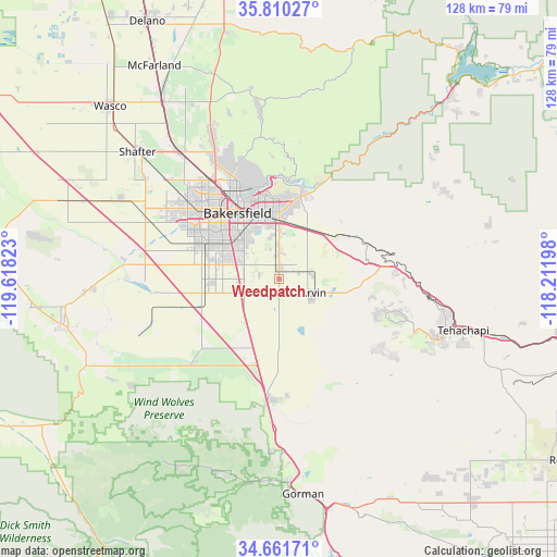
Weedpatch GPS coordinates[2]
35° 14' 16.872" North, 118° 54' 54.36" West
| Map corner | latitude | longitude |
|---|---|---|
| Upper-left | 35.81027°, | -119.61823° |
| Center: | 35.23802°, | -118.9151° |
| Lower-right: | 34.66171°, | -118.21198° |
| Map W x H: | 127.7×127.7 km | = 79.3×79.3mi |
| max Lat: | 71.29058° ⇑74% North |
| Weedpatch: | 35.23802° |
| min Lat: | ⇓26% South 19.06759° |
| min Long | Weedpatch | max Long |
| -171.73463° | -118.9151° | -66.98998° |
| W 8.2%⇐ | ⇒91.8% E |
Elevation
Elevation of Weedpatch is 117 m = 384 ft, and this is 177.8 m = 583 ft below average elevation for this country.
| Max E: |
3189 m = 10463 ft | 67.1% |
| Avg. | 294.8 m = 967 ft | |
| Weedpatch | 117 m = 384 ft | |
Min E: |
-60 m = -197 ft | 32.9% |
See also: United States elevation on elevation.city.
Geographical zone
Weedpatch is located in North temperate zone (between Tropic of Cancer and the Arctic Circle). Distance of this Northern Tropic circle is 1312.2 km =815.4 mi to South.| Distance of | km | miles | from Weedpatch |
|---|---|---|---|
| North Pole | 6089 | 3783.5 | to North |
| Arctic Circle | 3483.1 | 2164.3 | to North |
| Tropic Cancer | 1312.2 | 815.4 | to South |
| Equator | 3918.1 | 2434.6 | to South |


Nearby cities:
15 places around Weedpatch: (largest is in red/bold)
• Arvin
8.5 km =5.3 mi,  112°
112°
• Bakersfield
17.7 km =11 mi,  327°
327°
• Bear Valley Springs
27.5 km =17.1 mi, 108°
• Dustin Acres
43.2 km =26.8 mi,  267°
267°
• Fuller Acres
6.9 km =4.3 mi,  2°
2°
• Golden Hills
40 km =24.9 mi, 105°
• Greenacres
23.9 km =14.9 mi,  312°
312°
• Greenfield
8.7 km =5.4 mi,  293°
293°
• Lamont
2.4 km =1.5 mi, 1°
• Oildale
22.3 km =13.9 mi, 334°
• Rosedale
26.4 km =16.4 mi, 307°
• Shafter
43.6 km =27.1 mi, 312°
• Smith Corner
42.4 km =26.3 mi, 309°
• Stallion Springs
29.8 km =18.5 mi,  123°
123°
• Tehachapi
44 km =27.3 mi, 105°
Sources, notices
• [Note1] Compared only with cities in United States existing in our database
• [Src1] Map data: © OpenStreetMap contributors (CC-BY-SA)
• [Src2] Other city data from geonames.org with taken over terms of usage.
• [Src3] Geographical zone / Annual Mean Temperature by Robert A. Rohde @ Wikipedia
