Frazier Park geodata
Frazier Park (California) is a populated place; located in United States in America/Los_Angeles (GMT-7) time zone. With population of 2,691 people, there are 10200 cities with bigger population in this country. Compared to other cities in United States, 76.3% of cities are located further ↑North; 91.9% of cities are located further →East and 96.1% of cities have lower elevation than Frazier Park. Note1


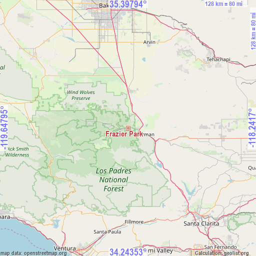
Frazier Park GPS coordinates[2]
34° 49' 21.936" North, 118° 56' 41.352" West
| Map corner | latitude | longitude |
|---|---|---|
| Upper-left | 35.39794°, | -119.64795° |
| Center: | 34.82276°, | -118.94482° |
| Lower-right: | 34.24353°, | -118.2417° |
| Map W x H: | 128.4×128.4 km | = 79.8×79.8mi |
| max Lat: | 71.29058° ⇑76.3% North |
| Frazier Park: | 34.82276° |
| min Lat: | ⇓23.7% South 19.06759° |
| min Long | Frazier Park | max Long |
| -171.73463° | -118.94482° | -66.98998° |
| W 8.1%⇐ | ⇒91.9% E |
Elevation
Elevation of Frazier Park is 1416 m = 4646 ft, and this is 1121.2 m = 3678 ft above average elevation for this country.
| Max E: |
3189 m = 10463 ft | 3.9% |
| Frazier Park | 1416 m 4646 ft | |
| Avg. | 294.8 m = 967 ft | |
Min E: |
-60 m = -197 ft | 96.1% |
See also: United States elevation on elevation.city.
Geographical zone
Frazier Park is located in North temperate zone (between Tropic of Cancer and the Arctic Circle). Distance of this Northern Tropic circle is 1266 km =786.7 mi to South.| Distance of | km | miles | from Frazier Park |
|---|---|---|---|
| North Pole | 6135.1 | 3812.2 | to North |
| Arctic Circle | 3529.2 | 2192.9 | to North |
| Tropic Cancer | 1266 | 786.7 | to South |
| Equator | 3871.9 | 2405.9 | to South |


Nearby cities:
15 places around Frazier Park: (largest is in red/bold)
• Arvin
44.2 km =27.5 mi,  13°
13°
• Bear Valley Springs
47.2 km =29.3 mi,  37°
37°
• Castaic
47.4 km =29.5 mi,  141°
141°
• Fillmore
47.2 km =29.3 mi,  177°
177°
• Lake Hughes
48.4 km =30.1 mi,  109°
109°
• Lake of the Woods
4.8 km =3 mi,  262°
262°
• Lamont
48.7 km =30.3 mi,  3°
3°
• Lebec
7.6 km =4.7 mi,  73°
73°
• Maricopa
49.2 km =30.6 mi,  302°
302°
• Ojai
49.8 km =30.9 mi,  213°
213°
• Pine Mountain Club
18.9 km =11.7 mi,  277°
277°
• Piru
47.4 km =29.5 mi,  163°
163°
• Stallion Springs
40.4 km =25.1 mi, 42°
• Val Verde
49.5 km =30.8 mi,  147°
147°
• Weedpatch
46.3 km =28.8 mi, 3°
Sources, notices
• [Note1] Compared only with cities in United States existing in our database
• [Src1] Map data: © OpenStreetMap contributors (CC-BY-SA)
• [Src2] Other city data from geonames.org with taken over terms of usage.
• [Src3] Geographical zone / Annual Mean Temperature by Robert A. Rohde @ Wikipedia
