Taft geodata
Taft (California) is a populated place; located in United States in America/Los_Angeles (GMT-7) time zone. With population of 9,495 people, there are 4623 cities with bigger population in this country. Compared to other cities in United States, 74.6% of cities are located further ↑North; 92.3% of cities are located further →East and 71.3% of cities have lower elevation than Taft. Note1


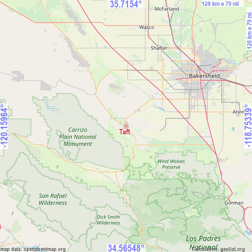
Taft GPS coordinates[2]
35° 8' 32.892" North, 119° 27' 23.436" West
| Map corner | latitude | longitude |
|---|---|---|
| Upper-left | 35.7154°, | -120.15964° |
| Center: | 35.14247°, | -119.45651° |
| Lower-right: | 34.56548°, | -118.75339° |
| Map W x H: | 127.9×127.9 km | = 79.5×79.5mi |
| max Lat: | 71.29058° ⇑74.6% North |
| Taft: | 35.14247° |
| min Lat: | ⇓25.4% South 19.06759° |
| min Long | Taft | max Long |
| -171.73463° | -119.45651° | -66.98998° |
| W 7.7%⇐ | ⇒92.3% E |
Elevation
Elevation of Taft is 292 m = 958 ft, and this is 2.8 m = 9 ft below average elevation for this country.
| Max E: |
3189 m = 10463 ft | 28.7% |
| Avg. | 294.8 m = 967 ft | |
| Taft | 292 m = 958 ft | |
Min E: |
-60 m = -197 ft | 71.3% |
See also: United States elevation on elevation.city.
Geographical zone
Taft is located in North temperate zone (between Tropic of Cancer and the Arctic Circle). Distance of this Northern Tropic circle is 1301.6 km =808.8 mi to South.| Distance of | km | miles | from Taft |
|---|---|---|---|
| North Pole | 6099.6 | 3790.1 | to North |
| Arctic Circle | 3493.7 | 2170.9 | to North |
| Tropic Cancer | 1301.6 | 808.8 | to South |
| Equator | 3907.5 | 2428 | to South |


Nearby cities:
15 places around Taft: (largest is in red/bold)
• Bakersfield
47.3 km =29.4 mi,  57°
57°
• Buttonwillow
28.7 km =17.8 mi,  357°
357°
• Dustin Acres
10.4 km =6.5 mi,  34°
34°
• Ford City
1.3 km =0.8 mi,  1°
1°
• Greenacres
41.3 km =25.7 mi,  49°
49°
• Greenfield
43.5 km =27 mi,  71°
71°
• Maricopa
10.6 km =6.6 mi,  151°
151°
• New Cuyama
30.1 km =18.7 mi,  223°
223°
• Pine Mountain Club
43.2 km =26.8 mi,  139°
139°
• Rosedale
38.9 km =24.2 mi, 46°
• Shafter
43.2 km =26.8 mi,  22°
22°
• Smith Corner
40.7 km =25.3 mi, 23°
• South Taft
0.9 km =0.6 mi,  178°
178°
• Taft Heights
1.7 km =1.1 mi,  239°
239°
• Valley Acres
8.4 km =5.2 mi, 32°
Sources, notices
• [Note1] Compared only with cities in United States existing in our database
• [Src1] Map data: © OpenStreetMap contributors (CC-BY-SA)
• [Src2] Other city data from geonames.org with taken over terms of usage.
• [Src3] Geographical zone / Annual Mean Temperature by Robert A. Rohde @ Wikipedia
