Prunedale geodata
Prunedale (California) is a populated place; located in United States in America/Los_Angeles (GMT-7) time zone. With population of 17,560 people, there are 2840 cities with bigger population in this country. Compared to other cities in United States, 67% of cities are located further ↑North; 94.5% of cities are located further →East and 86.2% of cities have higher elevation than Prunedale. Note1


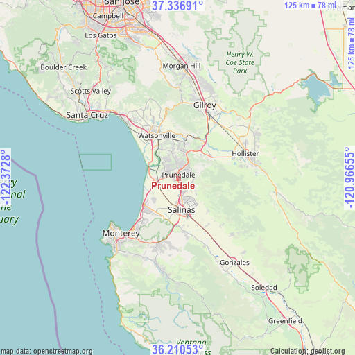
Prunedale GPS coordinates[2]
36° 46' 32.844" North, 121° 40' 10.812" West
| Map corner | latitude | longitude |
|---|---|---|
| Upper-left | 37.33691°, | -122.3728° |
| Center: | 36.77579°, | -121.66967° |
| Lower-right: | 36.21053°, | -120.96655° |
| Map W x H: | 125.2×125.2 km | = 77.8×77.8mi |
| max Lat: | 71.29058° ⇑67% North |
| Prunedale: | 36.77579° |
| min Lat: | ⇓33% South 19.06759° |
| min Long | Prunedale | max Long |
| -171.73463° | -121.66967° | -66.98998° |
| W 5.5%⇐ | ⇒94.5% E |
Elevation
Elevation of Prunedale is 25 m = 82 ft, and this is 269.8 m = 885 ft below average elevation for this country.
| Max E: |
3189 m = 10463 ft | 86.2% |
| Avg. | 294.8 m = 967 ft | |
| Prunedale | 25 m = 82 ft | |
Min E: |
-60 m = -197 ft | 13.8% |
See also: United States elevation on elevation.city.
Geographical zone
Prunedale is located in North temperate zone (between Tropic of Cancer and the Arctic Circle). Distance of this Northern Tropic circle is 1483.2 km =921.6 mi to South.| Distance of | km | miles | from Prunedale |
|---|---|---|---|
| North Pole | 5918 | 3677.3 | to North |
| Arctic Circle | 3312.1 | 2058 | to North |
| Tropic Cancer | 1483.2 | 921.6 | to South |
| Equator | 4089.1 | 2540.8 | to South |


Nearby cities:
15 places around Prunedale: (largest is in red/bold)
• Amesti
23 km =14.3 mi,  334°
334°
• Aromas
12.8 km =8 mi,  10°
10°
• Boronda
8.6 km =5.3 mi,  183°
183°
• Castroville
7.9 km =4.9 mi,  261°
261°
• Elkhorn
8.3 km =5.2 mi,  310°
310°
• Freedom
20 km =12.4 mi, 332°
• Interlaken
20.3 km =12.6 mi,  343°
343°
• Las Lomas
11.5 km =7.1 mi, 329°
• Marina
15.6 km =9.7 mi,  229°
229°
• Pajaro
15.9 km =9.9 mi, 333°
• Salinas
11 km =6.8 mi,  173°
173°
• San Juan Bautista
14.1 km =8.8 mi,  56°
56°
• Seaside
24.5 km =15.2 mi,  221°
221°
• Spreckels
17.2 km =10.7 mi, 173°
• Watsonville
16.8 km =10.4 mi, 332°
Sources, notices
• [Note1] Compared only with cities in United States existing in our database
• [Src1] Map data: © OpenStreetMap contributors (CC-BY-SA)
• [Src2] Other city data from geonames.org with taken over terms of usage.
• [Src3] Geographical zone / Annual Mean Temperature by Robert A. Rohde @ Wikipedia
