Las Lomas geodata
Las Lomas (California) is a populated place; located in United States in America/Los_Angeles (GMT-7) time zone. With population of 3,024 people, there are 9588 cities with bigger population in this country. Compared to other cities in United States, 66.7% of cities are located further ↑North; 94.6% of cities are located further →East and 92.1% of cities have higher elevation than Las Lomas. Note1


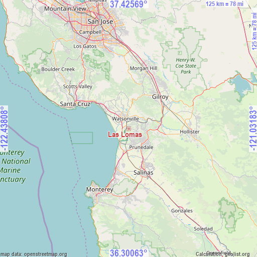
Las Lomas GPS coordinates[2]
36° 51' 54.828" North, 121° 44' 5.82" West
| Map corner | latitude | longitude |
|---|---|---|
| Upper-left | 37.42569°, | -122.43808° |
| Center: | 36.86523°, | -121.73495° |
| Lower-right: | 36.30063°, | -121.03183° |
| Map W x H: | 125.1×125.1 km | = 77.7×77.7mi |
| max Lat: | 71.29058° ⇑66.7% North |
| Las Lomas: | 36.86523° |
| min Lat: | ⇓33.3% South 19.06759° |
| min Long | Las Lomas | max Long |
| -171.73463° | -121.73495° | -66.98998° |
| W 5.4%⇐ | ⇒94.6% E |
Elevation
Elevation of Las Lomas is 12 m = 39 ft, and this is 282.8 m = 928 ft below average elevation for this country.
| Max E: |
3189 m = 10463 ft | 92.1% |
| Avg. | 294.8 m = 967 ft | |
| Las Lomas | 12 m = 39 ft | |
Min E: |
-60 m = -197 ft | 7.9% |
See also: United States elevation on elevation.city.
Geographical zone
Las Lomas is located in North temperate zone (between Tropic of Cancer and the Arctic Circle). Distance of this Northern Tropic circle is 1493.1 km =927.8 mi to South.| Distance of | km | miles | from Las Lomas |
|---|---|---|---|
| North Pole | 5908 | 3671.1 | to North |
| Arctic Circle | 3302.1 | 2051.8 | to North |
| Tropic Cancer | 1493.1 | 927.8 | to South |
| Equator | 4099 | 2547 | to South |


Nearby cities:
15 places around Las Lomas: (largest is in red/bold)
• Amesti
11.6 km =7.2 mi,  340°
340°
• Aptos
19.2 km =11.9 mi,  310°
310°
• Aptos Hills-Larkin Valley
13.8 km =8.6 mi,  320°
320°
• Aromas
8.6 km =5.3 mi,  72°
72°
• Castroville
11.2 km =7 mi,  190°
190°
• Corralitos
15.1 km =9.4 mi, 335°
• Elkhorn
4.6 km =2.9 mi, 186°
• Freedom
8.5 km =5.3 mi, 336°
• Interlaken
9.6 km =6 mi,  0°
0°
• La Selva Beach
14 km =8.7 mi,  304°
304°
• Pajaro
4.5 km =2.8 mi, 344°
• Prunedale
11.5 km =7.1 mi,  149°
149°
• Rio Del Mar
18.6 km =11.6 mi, 307°
• San Juan Bautista
17.7 km =11 mi,  97°
97°
• Watsonville
5.4 km =3.4 mi, 338°
Sources, notices
• [Note1] Compared only with cities in United States existing in our database
• [Src1] Map data: © OpenStreetMap contributors (CC-BY-SA)
• [Src2] Other city data from geonames.org with taken over terms of usage.
• [Src3] Geographical zone / Annual Mean Temperature by Robert A. Rohde @ Wikipedia
