Rancho Palos Verdes geodata
Rancho Palos Verdes (California) is a populated place; located in United States in America/Los_Angeles (GMT-7) time zone. With population of 42,732 people, there are 1122 cities with bigger population in this country. Compared to other cities in United States, 81.8% of cities are located further ↑North; 91.4% of cities are located further →East and 75.8% of cities have higher elevation than Rancho Palos Verdes. Note1


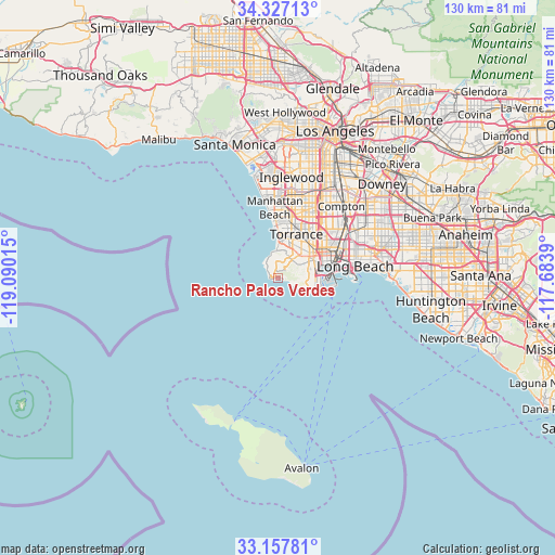
Rancho Palos Verdes GPS coordinates[2]
33° 44' 40.056" North, 118° 23' 13.272" West
| Map corner | latitude | longitude |
|---|---|---|
| Upper-left | 34.32713°, | -119.09015° |
| Center: | 33.74446°, | -118.38702° |
| Lower-right: | 33.15781°, | -117.6839° |
| Map W x H: | 130×130 km | = 80.8×80.8mi |
| max Lat: | 71.29058° ⇑81.8% North |
| Rancho Palos Verdes: | 33.74446° |
| min Lat: | ⇓18.2% South 19.06759° |
| min Long | Rancho Palos Ve | max Long |
| -171.73463° | -118.38702° | -66.98998° |
| W 8.6%⇐ | ⇒91.4% E |
Elevation
Elevation of Rancho Palos Verdes is 67 m = 220 ft, and this is 227.8 m = 747 ft below average elevation for this country.
| Max E: |
3189 m = 10463 ft | 75.8% |
| Avg. | 294.8 m = 967 ft | |
| Rancho Palos Verdes | 67 m = 220 ft | |
Min E: |
-60 m = -197 ft | 24.2% |
See also: Rancho Palos Verdes elevation on elevation.city.
Geographical zone
Rancho Palos Verdes is located in North temperate zone (between Tropic of Cancer and the Arctic Circle). Distance of this Northern Tropic circle is 1146.1 km =712.2 mi to South.| Distance of | km | miles | from Rancho Palos Verdes |
|---|---|---|---|
| North Pole | 6255 | 3886.7 | to North |
| Arctic Circle | 3649.1 | 2267.4 | to North |
| Tropic Cancer | 1146.1 | 712.2 | to South |
| Equator | 3752 | 2331.4 | to South |


Nearby cities:
15 places around Rancho Palos Verdes: (largest is in red/bold)
• Alondra Park
16.9 km =10.5 mi,  17°
17°
• Carson
13.7 km =8.5 mi,  45°
45°
• Gardena
17.5 km =10.9 mi, 24°
• Hermosa Beach
13.1 km =8.1 mi,  354°
354°
• Lawndale
16.2 km =10.1 mi,  11°
11°
• Lomita
8.5 km =5.3 mi, 51°
• Long Beach
18.5 km =11.5 mi,  82°
82°
• Manhattan Beach
15.8 km =9.8 mi, 351°
• Palos Verdes Estates
6.3 km =3.9 mi,  355°
355°
• Redondo Beach
11.6 km =7.2 mi, 359°
• Rolling Hills
3.1 km =1.9 mi,  62°
62°
• Rolling Hills Estates
5.5 km =3.4 mi,  28°
28°
• San Pedro
8.8 km =5.5 mi,  96°
96°
• Torrance
11 km =6.8 mi, 22°
• West Carson
12.2 km =7.6 mi, 45°
Sources, notices
• [Note1] Compared only with cities in United States existing in our database
• [Src1] Map data: © OpenStreetMap contributors (CC-BY-SA)
• [Src2] Other city data from geonames.org with taken over terms of usage.
• [Src3] Geographical zone / Annual Mean Temperature by Robert A. Rohde @ Wikipedia
