Seven Trees geodata
Seven Trees (California) is a section of populated place; located in United States in America/Los_Angeles (GMT-7) time zone. With population of 1,788 people, there are 12586 cities with bigger population in this country. Compared to other cities in United States, 64.9% of cities are located further ↑North; 94.8% of cities are located further →East and 79.9% of cities have higher elevation than Seven Trees. Note1


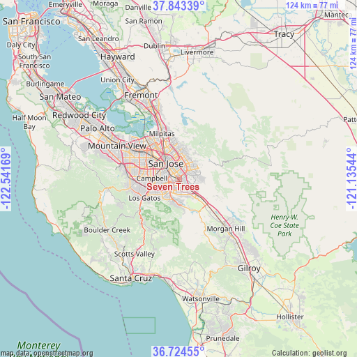
Seven Trees GPS coordinates[2]
37° 17' 9.78" North, 121° 50' 18.816" West
| Map corner | latitude | longitude |
|---|---|---|
| Upper-left | 37.84339°, | -122.54169° |
| Center: | 37.28605°, | -121.83856° |
| Lower-right: | 36.72455°, | -121.13544° |
| Map W x H: | 124.4×124.4 km | = 77.3×77.3mi |
| max Lat: | 71.29058° ⇑64.9% North |
| Seven Trees: | 37.28605° |
| min Lat: | ⇓35.1% South 19.06759° |
| min Long | Seven Trees | max Long |
| -171.73463° | -121.83856° | -66.98998° |
| W 5.2%⇐ | ⇒94.8% E |
Elevation
Elevation of Seven Trees is 47 m = 154 ft, and this is 247.8 m = 813 ft below average elevation for this country.
| Max E: |
3189 m = 10463 ft | 79.9% |
| Avg. | 294.8 m = 967 ft | |
| Seven Trees | 47 m = 154 ft | |
Min E: |
-60 m = -197 ft | 20.1% |
See also: United States elevation on elevation.city.
Geographical zone
Seven Trees is located in North temperate zone (between Tropic of Cancer and the Arctic Circle). Distance of this Northern Tropic circle is 1539.9 km =956.8 mi to South.| Distance of | km | miles | from Seven Trees |
|---|---|---|---|
| North Pole | 5861.2 | 3642 | to North |
| Arctic Circle | 3255.4 | 2022.8 | to North |
| Tropic Cancer | 1539.9 | 956.8 | to South |
| Equator | 4145.8 | 2576.1 | to South |


Nearby cities:
15 places around Seven Trees: (largest is in red/bold)
• Alum Rock
9 km =5.6 mi,  6°
6°
• Buena Vista
7.9 km =4.9 mi,  299°
299°
• Burbank
9.2 km =5.7 mi, 296°
• Cambrian Park
8.8 km =5.5 mi,  248°
248°
• Campbell
9.9 km =6.2 mi,  270°
270°
• Cupertino
17.6 km =10.9 mi,  283°
283°
• East Foothills
10.7 km =6.6 mi, 10°
• Fruitdale
8.8 km =5.5 mi,  288°
288°
• Lexington Hills
18 km =11.2 mi,  221°
221°
• Los Gatos
13.7 km =8.5 mi,  241°
241°
• Milpitas
16.9 km =10.5 mi,  339°
339°
• Monte Sereno
14.7 km =9.1 mi, 247°
• San Jose
7.7 km =4.8 mi,  319°
319°
• Santa Clara
12.8 km =8 mi,  306°
306°
• Saratoga
16.5 km =10.3 mi,  261°
261°
Sources, notices
• [Note1] Compared only with cities in United States existing in our database
• [Src1] Map data: © OpenStreetMap contributors (CC-BY-SA)
• [Src2] Other city data from geonames.org with taken over terms of usage.
• [Src3] Geographical zone / Annual Mean Temperature by Robert A. Rohde @ Wikipedia
