Campbell geodata
Campbell (California) is a populated place; located in United States in America/Los_Angeles (GMT-7) time zone. With population of 41,117 people, there are 1169 cities with bigger population in this country. Compared to other cities in United States, 64.9% of cities are located further ↑North; 94.9% of cities are located further →East and 77.7% of cities have higher elevation than Campbell. Note1


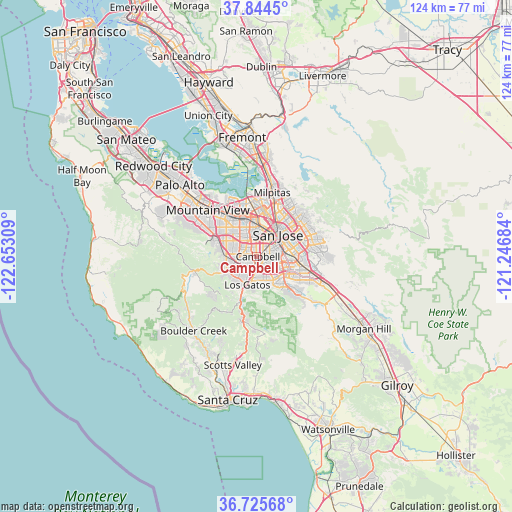
Campbell GPS coordinates[2]
37° 17' 13.812" North, 121° 56' 59.856" West
| Map corner | latitude | longitude |
|---|---|---|
| Upper-left | 37.8445°, | -122.65309° |
| Center: | 37.28717°, | -121.94996° |
| Lower-right: | 36.72568°, | -121.24684° |
| Map W x H: | 124.4×124.4 km | = 77.3×77.3mi |
| max Lat: | 71.29058° ⇑64.9% North |
| Campbell: | 37.28717° |
| min Lat: | ⇓35.1% South 19.06759° |
| min Long | Campbell | max Long |
| -171.73463° | -121.94996° | -66.98998° |
| W 5.1%⇐ | ⇒94.9% E |
Elevation
Elevation of Campbell is 57 m = 187 ft, and this is 237.8 m = 780 ft below average elevation for this country.
| Max E: |
3189 m = 10463 ft | 77.7% |
| Avg. | 294.8 m = 967 ft | |
| Campbell | 57 m = 187 ft | |
Min E: |
-60 m = -197 ft | 22.3% |
See also: Campbell elevation on elevation.city.
Geographical zone
Campbell is located in North temperate zone (between Tropic of Cancer and the Arctic Circle). Distance of this Northern Tropic circle is 1540 km =956.9 mi to South.| Distance of | km | miles | from Campbell |
|---|---|---|---|
| North Pole | 5861.1 | 3641.9 | to North |
| Arctic Circle | 3255.2 | 2022.7 | to North |
| Tropic Cancer | 1540 | 956.9 | to South |
| Equator | 4145.9 | 2576.1 | to South |


Nearby cities:
15 places around Campbell: (largest is in red/bold)
• Alum Rock
14 km =8.7 mi,  51°
51°
• Buena Vista
4.8 km =3 mi,  37°
37°
• Burbank
4.3 km =2.7 mi,  21°
21°
• Cambrian Park
3.8 km =2.4 mi,  153°
153°
• Cupertino
8.3 km =5.2 mi,  298°
298°
• Fruitdale
3 km =1.9 mi,  30°
30°
• Lexington Hills
13.8 km =8.6 mi,  188°
188°
• Los Gatos
7.1 km =4.4 mi,  197°
197°
• Loyola
15.1 km =9.4 mi, 298°
• Monte Sereno
6.8 km =4.2 mi,  213°
213°
• San Jose
7.6 km =4.7 mi, 39°
• Santa Clara
7.5 km =4.7 mi,  356°
356°
• Saratoga
7 km =4.3 mi,  248°
248°
• Seven Trees
9.9 km =6.2 mi,  90°
90°
• Sunnyvale
11.9 km =7.4 mi,  319°
319°
Sources, notices
• [Note1] Compared only with cities in United States existing in our database
• [Src1] Map data: © OpenStreetMap contributors (CC-BY-SA)
• [Src2] Other city data from geonames.org with taken over terms of usage.
• [Src3] Geographical zone / Annual Mean Temperature by Robert A. Rohde @ Wikipedia
