Yountville geodata
Yountville (California) is a populated place; located in United States in America/Los_Angeles (GMT-7) time zone. With population of 3,017 people, there are 9594 cities with bigger population in this country. Compared to other cities in United States, 59.4% of cities are located further ↑North; 96.2% of cities are located further →East and 84.4% of cities have higher elevation than Yountville. Note1


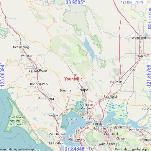
Yountville GPS coordinates[2]
38° 24' 5.688" North, 122° 21' 38.916" West
| Map corner | latitude | longitude |
|---|---|---|
| Upper-left | 38.9505°, | -123.06394° |
| Center: | 38.40158°, | -122.36081° |
| Lower-right: | 37.84846°, | -121.65769° |
| Map W x H: | 122.5×122.5 km | = 76.1×76.1mi |
| max Lat: | 71.29058° ⇑59.4% North |
| Yountville: | 38.40158° |
| min Lat: | ⇓40.6% South 19.06759° |
| min Long | Yountville | max Long |
| -171.73463° | -122.36081° | -66.98998° |
| W 3.8%⇐ | ⇒96.2% E |
Elevation
Elevation of Yountville is 30 m = 98 ft, and this is 264.8 m = 869 ft below average elevation for this country.
| Max E: |
3189 m = 10463 ft | 84.4% |
| Avg. | 294.8 m = 967 ft | |
| Yountville | 30 m = 98 ft | |
Min E: |
-60 m = -197 ft | 15.6% |
See also: United States elevation on elevation.city.
Geographical zone
Yountville is located in North temperate zone (between Tropic of Cancer and the Arctic Circle). Distance of this Northern Tropic circle is 1663.9 km =1033.9 mi to South.| Distance of | km | miles | from Yountville |
|---|---|---|---|
| North Pole | 5737.2 | 3564.9 | to North |
| Arctic Circle | 3131.3 | 1945.7 | to North |
| Tropic Cancer | 1663.9 | 1033.9 | to South |
| Equator | 4269.9 | 2653.2 | to South |


Nearby cities:
15 places around Yountville: (largest is in red/bold)
• American Canyon
26.7 km =16.6 mi,  160°
160°
• Angwin
20.9 km =13 mi,  338°
338°
• Boyes Hot Springs
14.4 km =8.9 mi,  227°
227°
• Calistoga
27.4 km =17 mi,  315°
315°
• Deer Park
17.4 km =10.8 mi,  326°
326°
• El Verano
16.2 km =10.1 mi,  224°
224°
• Eldridge
14.3 km =8.9 mi,  245°
245°
• Fetters Hot Springs-Agua Caliente
14.1 km =8.8 mi, 230°
• Glen Ellen
14.8 km =9.2 mi, 253°
• Green Valley
23.9 km =14.9 mi,  133°
133°
• Kenwood
16.2 km =10.1 mi,  274°
274°
• Napa
13.3 km =8.3 mi,  150°
150°
• Saint Helena
15 km =9.3 mi, 320°
• Sonoma
14.9 km =9.3 mi,  214°
214°
• Temelec
18.9 km =11.7 mi, 217°
Sources, notices
• [Note1] Compared only with cities in United States existing in our database
• [Src1] Map data: © OpenStreetMap contributors (CC-BY-SA)
• [Src2] Other city data from geonames.org with taken over terms of usage.
• [Src3] Geographical zone / Annual Mean Temperature by Robert A. Rohde @ Wikipedia
