Napa geodata
Napa (California) is a seat of a second-order administrative division; located in United States in America/Los_Angeles (GMT-7) time zone. With population of 80,434 people, there are 491 cities with bigger population in this country. Compared to other cities in United States, 60% of cities are located further ↑North; 96% of cities are located further →East and 94.8% of cities have higher elevation than Napa. Note1


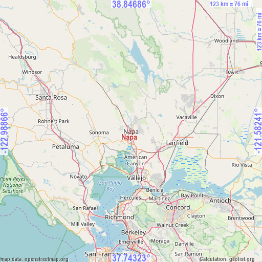
Napa GPS coordinates[2]
38° 17' 49.704" North, 122° 17' 7.908" West
| Map corner | latitude | longitude |
|---|---|---|
| Upper-left | 38.84686°, | -122.98866° |
| Center: | 38.29714°, | -122.28553° |
| Lower-right: | 37.74323°, | -121.58241° |
| Map W x H: | 122.7×122.7 km | = 76.2×76.2mi |
| max Lat: | 71.29058° ⇑60% North |
| Napa: | 38.29714° |
| min Lat: | ⇓40% South 19.06759° |
| min Long | Napa | max Long |
| -171.73463° | -122.28553° | -66.98998° |
| W 4%⇐ | ⇒96% E |
Elevation
Elevation of Napa is 9 m = 30 ft, and this is 285.8 m = 938 ft below average elevation for this country.
| Max E: |
3189 m = 10463 ft | 94.8% |
| Avg. | 294.8 m = 967 ft | |
| Napa | 9 m = 30 ft | |
Min E: |
-60 m = -197 ft | 5.2% |
See also: Napa elevation on elevation.city.
Geographical zone
Napa is located in North temperate zone (between Tropic of Cancer and the Arctic Circle). Distance of this Northern Tropic circle is 1652.3 km =1026.7 mi to South.| Distance of | km | miles | from Napa |
|---|---|---|---|
| North Pole | 5748.8 | 3572.1 | to North |
| Arctic Circle | 3142.9 | 1952.9 | to North |
| Tropic Cancer | 1652.3 | 1026.7 | to South |
| Equator | 4258.2 | 2645.9 | to South |


Nearby cities:
15 places around Napa: (largest is in red/bold)
• American Canyon
13.8 km =8.6 mi,  170°
170°
• Boyes Hot Springs
17.2 km =10.7 mi,  276°
276°
• El Verano
18 km =11.2 mi,  270°
270°
• Eldridge
20.5 km =12.7 mi,  286°
286°
• Fairfield
22.1 km =13.7 mi,  103°
103°
• Fetters Hot Springs-Agua Caliente
17.8 km =11.1 mi, 278°
• Glen Ellen
22.1 km =13.7 mi, 289°
• Green Valley
11.8 km =7.3 mi,  114°
114°
• Kenwood
26.2 km =16.3 mi,  299°
299°
• Sonoma
15.1 km =9.4 mi, 267°
• Suisun
22.4 km =13.9 mi, 107°
• Temelec
18.4 km =11.4 mi,  259°
259°
• Vacaville
26.8 km =16.7 mi,  75°
75°
• Vallejo
21.6 km =13.4 mi, 173°
• Yountville
13.3 km =8.3 mi,  330°
330°
Sources, notices
• [Note1] Compared only with cities in United States existing in our database
• [Src1] Map data: © OpenStreetMap contributors (CC-BY-SA)
• [Src2] Other city data from geonames.org with taken over terms of usage.
• [Src3] Geographical zone / Annual Mean Temperature by Robert A. Rohde @ Wikipedia
