Springville geodata
Springville (California) is a populated place; located in United States in America/Los_Angeles (GMT-7) time zone. With population of 934 people, there are 16762 cities with bigger population in this country. Compared to other cities in United States, 69.7% of cities are located further ↑North; 91.8% of cities are located further →East and 75.1% of cities have lower elevation than Springville. Note1


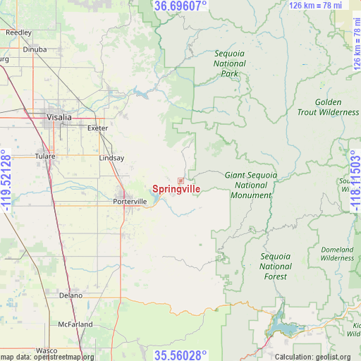
Springville GPS coordinates[2]
36° 7' 48.828" North, 118° 49' 5.34" West
| Map corner | latitude | longitude |
|---|---|---|
| Upper-left | 36.69607°, | -119.52128° |
| Center: | 36.13023°, | -118.81815° |
| Lower-right: | 35.56028°, | -118.11503° |
| Map W x H: | 126.3×126.3 km | = 78.5×78.5mi |
| max Lat: | 71.29058° ⇑69.7% North |
| Springville: | 36.13023° |
| min Lat: | ⇓30.3% South 19.06759° |
| min Long | Springville | max Long |
| -171.73463° | -118.81815° | -66.98998° |
| W 8.2%⇐ | ⇒91.8% E |
Elevation
Elevation of Springville is 314 m = 1030 ft, and this is 19.2 m = 63 ft above average elevation for this country.
| Max E: |
3189 m = 10463 ft | 24.9% |
| Springville | 314 m 1030 ft | |
| Avg. | 294.8 m = 967 ft | |
Min E: |
-60 m = -197 ft | 75.1% |
See also: United States elevation on elevation.city.
Geographical zone
Springville is located in North temperate zone (between Tropic of Cancer and the Arctic Circle). Distance of this Northern Tropic circle is 1411.4 km =877 mi to South.| Distance of | km | miles | from Springville |
|---|---|---|---|
| North Pole | 5989.8 | 3721.9 | to North |
| Arctic Circle | 3383.9 | 2102.7 | to North |
| Tropic Cancer | 1411.4 | 877 | to South |
| Equator | 4017.3 | 2496.2 | to South |


Nearby cities:
15 places around Springville: (largest is in red/bold)
• Ducor
33.6 km =20.9 mi,  217°
217°
• East Porterville
16.3 km =10.1 mi,  240°
240°
• East Tulare Villa
42.4 km =26.3 mi,  281°
281°
• Exeter
34.4 km =21.4 mi,  302°
302°
• Farmersville
39.5 km =24.5 mi, 298°
• Lindsay
25.6 km =15.9 mi,  288°
288°
• Linnell Camp
41.4 km =25.7 mi, 298°
• Plainview
28.4 km =17.6 mi,  273°
273°
• Poplar-Cotton Center
30.9 km =19.2 mi,  254°
254°
• Porterville
19.3 km =12 mi, 247°
• Strathmore
21.8 km =13.5 mi, 274°
• Terra Bella
27.6 km =17.1 mi,  227°
227°
• Three Rivers
35.2 km =21.9 mi,  347°
347°
• Woodlake
40.3 km =25 mi,  321°
321°
• Woodville
34.5 km =21.4 mi,  263°
263°
Sources, notices
• [Note1] Compared only with cities in United States existing in our database
• [Src1] Map data: © OpenStreetMap contributors (CC-BY-SA)
• [Src2] Other city data from geonames.org with taken over terms of usage.
• [Src3] Geographical zone / Annual Mean Temperature by Robert A. Rohde @ Wikipedia
