East Tulare Villa geodata
East Tulare Villa (California) is a populated place; located in United States in America/Los_Angeles (GMT-7) time zone. With population of 778 people, there are 17996 cities with bigger population in this country. Compared to other cities in United States, 69.4% of cities are located further ↑North; 92.2% of cities are located further →East and 71.5% of cities have higher elevation than East Tulare Villa. Note1


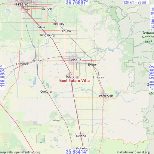
East Tulare Villa GPS coordinates[2]
36° 12' 12.816" North, 119° 16' 55.812" West
| Map corner | latitude | longitude |
|---|---|---|
| Upper-left | 36.76887°, | -119.9853° |
| Center: | 36.20356°, | -119.28217° |
| Lower-right: | 35.63414°, | -118.57905° |
| Map W x H: | 126.2×126.2 km | = 78.4×78.4mi |
| max Lat: | 71.29058° ⇑69.4% North |
| East Tulare Villa: | 36.20356° |
| min Lat: | ⇓30.6% South 19.06759° |
| min Long | East Tulare Vil | max Long |
| -171.73463° | -119.28217° | -66.98998° |
| W 7.8%⇐ | ⇒92.2% E |
Elevation
Elevation of East Tulare Villa is 92 m = 302 ft, and this is 202.8 m = 665 ft below average elevation for this country.
| Max E: |
3189 m = 10463 ft | 71.5% |
| Avg. | 294.8 m = 967 ft | |
| East Tulare Villa | 92 m = 302 ft | |
Min E: |
-60 m = -197 ft | 28.5% |
See also: United States elevation on elevation.city.
Geographical zone
East Tulare Villa is located in North temperate zone (between Tropic of Cancer and the Arctic Circle). Distance of this Northern Tropic circle is 1419.5 km =882 mi to South.| Distance of | km | miles | from East Tulare Villa |
|---|---|---|---|
| North Pole | 5981.6 | 3716.8 | to North |
| Arctic Circle | 3375.7 | 2097.6 | to North |
| Tropic Cancer | 1419.5 | 882 | to South |
| Equator | 4025.5 | 2501.3 | to South |


Nearby cities:
15 places around East Tulare Villa: (largest is in red/bold)
• Exeter
16.2 km =10.1 mi,  50°
50°
• Farmersville
12.5 km =7.8 mi,  32°
32°
• Goshen
20.5 km =12.7 mi,  322°
322°
• Ivanhoe
21.2 km =13.2 mi,  15°
15°
• Lindsay
17.4 km =10.8 mi,  90°
90°
• Linnell Camp
12.9 km =8 mi, 24°
• Matheny
7.2 km =4.5 mi,  239°
239°
• Patterson Tract
19.6 km =12.2 mi,  356°
356°
• Plainview
14.9 km =9.3 mi,  116°
116°
• Poplar-Cotton Center
20.3 km =12.6 mi,  143°
143°
• Strathmore
20.9 km =13 mi,  107°
107°
• Tipton
16.3 km =10.1 mi,  189°
189°
• Tulare
5.9 km =3.7 mi,  274°
274°
• Visalia
14.1 km =8.8 mi, 356°
• Woodville
14.3 km =8.9 mi,  148°
148°
Sources, notices
• [Note1] Compared only with cities in United States existing in our database
• [Src1] Map data: © OpenStreetMap contributors (CC-BY-SA)
• [Src2] Other city data from geonames.org with taken over terms of usage.
• [Src3] Geographical zone / Annual Mean Temperature by Robert A. Rohde @ Wikipedia
