Porterville geodata
Porterville (California) is a populated place; located in United States in America/Los_Angeles (GMT-7) time zone. With population of 56,058 people, there are 814 cities with bigger population in this country. Compared to other cities in United States, 70.1% of cities are located further ↑North; 91.9% of cities are located further →East and 62.1% of cities have higher elevation than Porterville. Note1


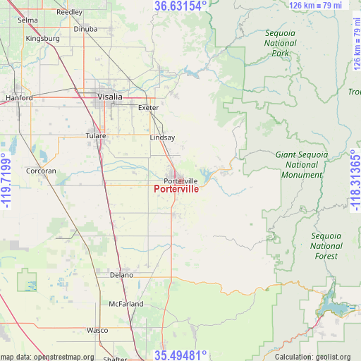
Porterville GPS coordinates[2]
36° 3' 54.828" North, 119° 1' 0.372" West
| Map corner | latitude | longitude |
|---|---|---|
| Upper-left | 36.63154°, | -119.7199° |
| Center: | 36.06523°, | -119.01677° |
| Lower-right: | 35.49481°, | -118.31365° |
| Map W x H: | 126.4×126.4 km | = 78.5×78.5mi |
| max Lat: | 71.29058° ⇑70.1% North |
| Porterville: | 36.06523° |
| min Lat: | ⇓29.9% South 19.06759° |
| min Long | Porterville | max Long |
| -171.73463° | -119.01677° | -66.98998° |
| W 8.1%⇐ | ⇒91.9% E |
Elevation
Elevation of Porterville is 144 m = 472 ft, and this is 150.8 m = 495 ft below average elevation for this country.
| Max E: |
3189 m = 10463 ft | 62.1% |
| Avg. | 294.8 m = 967 ft | |
| Porterville | 144 m = 472 ft | |
Min E: |
-60 m = -197 ft | 37.9% |
See also: Porterville elevation on elevation.city.
Geographical zone
Porterville is located in North temperate zone (between Tropic of Cancer and the Arctic Circle). Distance of this Northern Tropic circle is 1404.2 km =872.5 mi to South.| Distance of | km | miles | from Porterville |
|---|---|---|---|
| North Pole | 5997 | 3726.4 | to North |
| Arctic Circle | 3391.1 | 2107.1 | to North |
| Tropic Cancer | 1404.2 | 872.5 | to South |
| Equator | 4010.1 | 2491.8 | to South |


Nearby cities:
15 places around Porterville: (largest is in red/bold)
• Ducor
19.5 km =12.1 mi,  188°
188°
• Earlimart
30.6 km =19 mi,  228°
228°
• East Porterville
3.8 km =2.4 mi,  103°
103°
• East Tulare Villa
28.4 km =17.6 mi,  302°
302°
• Exeter
28 km =17.4 mi,  336°
336°
• Lindsay
16.6 km =10.3 mi, 337°
• Pixley
27 km =16.8 mi,  246°
246°
• Plainview
13.7 km =8.5 mi,  309°
309°
• Poplar-Cotton Center
11.9 km =7.4 mi,  265°
265°
• Springville
19.3 km =12 mi,  67°
67°
• Strathmore
9.8 km =6.1 mi, 336°
• Terra Bella
11.7 km =7.3 mi, 192°
• Teviston
28 km =17.4 mi,  237°
237°
• Tipton
26.5 km =16.5 mi, 268°
• Woodville
16.7 km =10.4 mi,  280°
280°
Sources, notices
• [Note1] Compared only with cities in United States existing in our database
• [Src1] Map data: © OpenStreetMap contributors (CC-BY-SA)
• [Src2] Other city data from geonames.org with taken over terms of usage.
• [Src3] Geographical zone / Annual Mean Temperature by Robert A. Rohde @ Wikipedia
