Twentynine Palms geodata
Twentynine Palms (California) is a populated place; located in United States in America/Los_Angeles (GMT-7) time zone. With population of 26,025 people, there are 1926 cities with bigger population in this country. Compared to other cities in United States, 79.4% of cities are located further ↑North; 89.1% of cities are located further →East and 89.7% of cities have lower elevation than Twentynine Palms. Note1


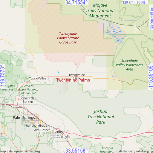
Twentynine Palms GPS coordinates[2]
34° 8' 8.016" North, 116° 3' 15.012" West
| Map corner | latitude | longitude |
|---|---|---|
| Upper-left | 34.71554°, | -116.7573° |
| Center: | 34.13556°, | -116.05417° |
| Lower-right: | 33.55158°, | -115.35105° |
| Map W x H: | 129.4×129.4 km | = 80.4×80.4mi |
| max Lat: | 71.29058° ⇑79.4% North |
| Twentynine Palms: | 34.13556° |
| min Lat: | ⇓20.6% South 19.06759° |
| min Long | Twentynine Palm | max Long |
| -171.73463° | -116.05417° | -66.98998° |
| W 10.9%⇐ | ⇒89.1% E |
Elevation
Elevation of Twentynine Palms is 607 m = 1991 ft, and this is 312.2 m = 1024 ft above average elevation for this country.
| Max E: |
3189 m = 10463 ft | 10.3% |
| Twentynine Palms | 607 m 1991 ft | |
| Avg. | 294.8 m = 967 ft | |
Min E: |
-60 m = -197 ft | 89.7% |
See also: United States elevation on elevation.city.
Geographical zone
Twentynine Palms is located in North temperate zone (between Tropic of Cancer and the Arctic Circle). Distance of this Northern Tropic circle is 1189.6 km =739.2 mi to South.| Distance of | km | miles | from Twentynine Palms |
|---|---|---|---|
| North Pole | 6211.5 | 3859.6 | to North |
| Arctic Circle | 3605.7 | 2240.5 | to North |
| Tropic Cancer | 1189.6 | 739.2 | to South |
| Equator | 3795.5 | 2358.4 | to South |


Nearby cities:
15 places around Twentynine Palms: (largest is in red/bold)
• Bermuda Dunes
48.8 km =30.3 mi,  206°
206°
• Cathedral City
54.8 km =34.1 mi,  223°
223°
• Coachella
51.8 km =32.2 mi,  192°
192°
• Desert Edge
42.7 km =26.5 mi,  236°
236°
• Desert Hot Springs
45.7 km =28.4 mi, 244°
• Garnet
52.2 km =32.4 mi, 240°
• Indian Wells
53.5 km =33.2 mi, 209°
• Indio
48.5 km =30.1 mi,  198°
198°
• Indio Hills
37.6 km =23.4 mi, 205°
• Joshua Tree
23.8 km =14.8 mi,  269°
269°
• Morongo Valley
49.5 km =30.8 mi,  258°
258°
• Palm Desert
54.7 km =34 mi, 212°
• Sky Valley
38.7 km =24 mi,  225°
225°
• Thousand Palms
46.8 km =29.1 mi, 221°
• Yucca Valley
34.9 km =21.7 mi, 266°
Sources, notices
• [Note1] Compared only with cities in United States existing in our database
• [Src1] Map data: © OpenStreetMap contributors (CC-BY-SA)
• [Src2] Other city data from geonames.org with taken over terms of usage.
• [Src3] Geographical zone / Annual Mean Temperature by Robert A. Rohde @ Wikipedia
