Valencia geodata
Valencia (California) is a populated place; located in United States in America/Los_Angeles (GMT-7) time zone. With population of 148,456 people, there are 198 cities with bigger population in this country. Compared to other cities in United States, 77.9% of cities are located further ↑North; 91.7% of cities are located further →East and 74.9% of cities have lower elevation than Valencia. Note1


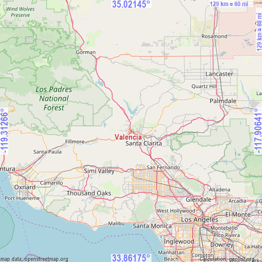
Valencia GPS coordinates[2]
34° 26' 36.996" North, 118° 36' 34.308" West
| Map corner | latitude | longitude |
|---|---|---|
| Upper-left | 35.02145°, | -119.31266° |
| Center: | 34.44361°, | -118.60953° |
| Lower-right: | 33.86175°, | -117.90641° |
| Map W x H: | 128.9×128.9 km | = 80.1×80.1mi |
| max Lat: | 71.29058° ⇑77.9% North |
| Valencia: | 34.44361° |
| min Lat: | ⇓22.1% South 19.06759° |
| min Long | Valencia | max Long |
| -171.73463° | -118.60953° | -66.98998° |
| W 8.3%⇐ | ⇒91.7% E |
Elevation
Elevation of Valencia is 312 m = 1024 ft, and this is 17.2 m = 56 ft above average elevation for this country.
| Max E: |
3189 m = 10463 ft | 25.1% |
| Valencia | 312 m 1024 ft | |
| Avg. | 294.8 m = 967 ft | |
Min E: |
-60 m = -197 ft | 74.9% |
See also: Valencia elevation on elevation.city.
Geographical zone
Valencia is located in North temperate zone (between Tropic of Cancer and the Arctic Circle). Distance of this Northern Tropic circle is 1223.9 km =760.5 mi to South.| Distance of | km | miles | from Valencia |
|---|---|---|---|
| North Pole | 6177.3 | 3838.4 | to North |
| Arctic Circle | 3571.4 | 2219.2 | to North |
| Tropic Cancer | 1223.9 | 760.5 | to South |
| Equator | 3829.8 | 2379.7 | to South |


Nearby cities:
15 places around Valencia: (largest is in red/bold)
• Agua Dulce
26.7 km =16.6 mi,  77°
77°
• Canoga Park
27 km =16.8 mi,  177°
177°
• Castaic
5.2 km =3.2 mi,  346°
346°
• Chatsworth
20.7 km =12.9 mi, 177°
• Green Valley
26.7 km =16.6 mi,  42°
42°
• North Hills
25.7 km =16 mi,  153°
153°
• Northridge
24.9 km =15.5 mi,  164°
164°
• Piru
17.2 km =10.7 mi,  259°
259°
• San Fernando
23.8 km =14.8 mi,  138°
138°
• Santa Clarita
8.4 km =5.2 mi,  133°
133°
• Santa Susana
21.2 km =13.2 mi,  205°
205°
• Simi Valley
25 km =15.5 mi,  219°
219°
• Stevenson Ranch
6.8 km =4.2 mi, 150°
• Val Verde
4.4 km =2.7 mi,  272°
272°
• West Hills
27.6 km =17.1 mi,  186°
186°
Sources, notices
• [Note1] Compared only with cities in United States existing in our database
• [Src1] Map data: © OpenStreetMap contributors (CC-BY-SA)
• [Src2] Other city data from geonames.org with taken over terms of usage.
• [Src3] Geographical zone / Annual Mean Temperature by Robert A. Rohde @ Wikipedia
