Castaic geodata
Castaic (California) is a populated place; located in United States in America/Los_Angeles (GMT-7) time zone. With population of 19,015 people, there are 2650 cities with bigger population in this country. Compared to other cities in United States, 77.7% of cities are located further ↑North; 91.7% of cities are located further →East and 81.8% of cities have lower elevation than Castaic. Note1


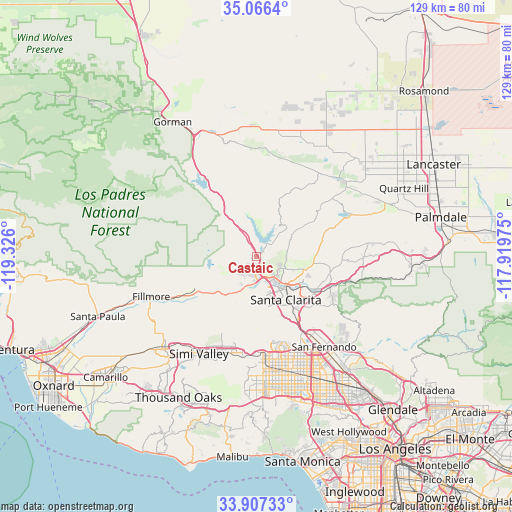
Castaic GPS coordinates[2]
34° 29' 19.968" North, 118° 37' 22.332" West
| Map corner | latitude | longitude |
|---|---|---|
| Upper-left | 35.0664°, | -119.326° |
| Center: | 34.48888°, | -118.62287° |
| Lower-right: | 33.90733°, | -117.91975° |
| Map W x H: | 128.9×128.9 km | = 80.1×80.1mi |
| max Lat: | 71.29058° ⇑77.7% North |
| Castaic: | 34.48888° |
| min Lat: | ⇓22.3% South 19.06759° |
| min Long | Castaic | max Long |
| -171.73463° | -118.62287° | -66.98998° |
| W 8.3%⇐ | ⇒91.7% E |
Elevation
Elevation of Castaic is 374 m = 1227 ft, and this is 79.2 m = 260 ft above average elevation for this country.
| Max E: |
3189 m = 10463 ft | 18.2% |
| Castaic | 374 m 1227 ft | |
| Avg. | 294.8 m = 967 ft | |
Min E: |
-60 m = -197 ft | 81.8% |
See also: United States elevation on elevation.city.
Geographical zone
Castaic is located in North temperate zone (between Tropic of Cancer and the Arctic Circle). Distance of this Northern Tropic circle is 1228.9 km =763.6 mi to South.| Distance of | km | miles | from Castaic |
|---|---|---|---|
| North Pole | 6172.3 | 3835.3 | to North |
| Arctic Circle | 3566.4 | 2216.1 | to North |
| Tropic Cancer | 1228.9 | 763.6 | to South |
| Equator | 3834.8 | 2382.8 | to South |


Nearby cities:
15 places around Castaic: (largest is in red/bold)
• Agua Dulce
27.3 km =17 mi,  88°
88°
• Chatsworth
25.8 km =16 mi,  175°
175°
• Fillmore
28.9 km =18 mi,  249°
249°
• Green Valley
24.2 km =15 mi,  52°
52°
• Lake Hughes
26.5 km =16.5 mi,  37°
37°
• North Hills
30.8 km =19.1 mi,  155°
155°
• Northridge
30 km =18.6 mi, 164°
• Piru
17.7 km =11 mi,  242°
242°
• San Fernando
28.5 km =17.7 mi,  143°
143°
• Santa Clarita
13.1 km =8.1 mi,  145°
145°
• Santa Susana
25.4 km =15.8 mi,  198°
198°
• Simi Valley
28.4 km =17.6 mi,  210°
210°
• Stevenson Ranch
11.8 km =7.3 mi, 157°
• Val Verde
5.8 km =3.6 mi, 213°
• Valencia
5.2 km =3.2 mi,  166°
166°
Sources, notices
• [Note1] Compared only with cities in United States existing in our database
• [Src1] Map data: © OpenStreetMap contributors (CC-BY-SA)
• [Src2] Other city data from geonames.org with taken over terms of usage.
• [Src3] Geographical zone / Annual Mean Temperature by Robert A. Rohde @ Wikipedia
