Vallejo geodata
Vallejo (California) is a populated place; located in United States in America/Los_Angeles (GMT-7) time zone. With population of 121,253 people, there are 258 cities with bigger population in this country. Compared to other cities in United States, 61.1% of cities are located further ↑North; 95.8% of cities are located further →East and 87.4% of cities have higher elevation than Vallejo. Note1


Vallejo GPS coordinates[2]
38° 6' 14.724" North, 122° 15' 23.904" West
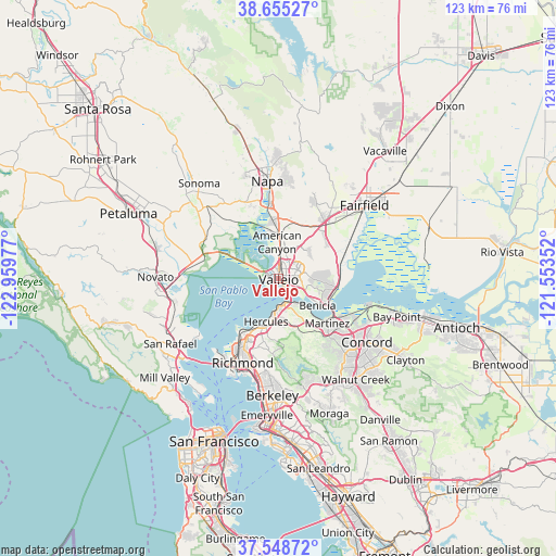
| Map corner | latitude | longitude |
|---|---|---|
| Upper-left | 38.65527°, | -122.95977° |
| Center: | 38.10409°, | -122.25664° |
| Lower-right: | 37.54872°, | -121.55352° |
| Map W x H: | 123×123 km | = 76.4×76.4mi |
| max Lat: | 71.29058° ⇑61.1% North |
| Vallejo: | 38.10409° |
| min Lat: | ⇓38.9% South 19.06759° |
| min Long | Vallejo | max Long |
| -171.73463° | -122.25664° | -66.98998° |
| W 4.2%⇐ | ⇒95.8% E |
Elevation
Elevation of Vallejo is 22 m = 72 ft, and this is 272.8 m = 895 ft below average elevation for this country.
| Max E: |
3189 m = 10463 ft | 87.4% |
| Avg. | 294.8 m = 967 ft | |
| Vallejo | 22 m = 72 ft | |
Min E: |
-60 m = -197 ft | 12.6% |
See also: Vallejo elevation on elevation.city.
Geographical zone
Vallejo is located in North temperate zone (between Tropic of Cancer and the Arctic Circle). Distance of this Northern Tropic circle is 1630.9 km =1013.4 mi to South.| Distance of | km | miles | from Vallejo |
|---|---|---|---|
| North Pole | 5770.3 | 3585.5 | to North |
| Arctic Circle | 3164.4 | 1966.3 | to North |
| Tropic Cancer | 1630.9 | 1013.4 | to South |
| Equator | 4236.8 | 2632.6 | to South |


Nearby cities:
15 places around Vallejo: (largest is in red/bold)
• American Canyon
7.9 km =4.9 mi,  357°
357°
• Bayview
12.1 km =7.5 mi,  206°
206°
• Benicia
10.5 km =6.5 mi,  125°
125°
• Crockett
6.9 km =4.3 mi,  146°
146°
• El Sobrante
14.5 km =9 mi,  193°
193°
• Hercules
10.1 km =6.3 mi,  196°
196°
• Martinez
14.3 km =8.9 mi, 131°
• Montalvin
13.8 km =8.6 mi, 208°
• Mountain View
16.1 km =10 mi, 131°
• Pinole
11.7 km =7.3 mi, 198°
• Rodeo
8 km =5 mi, 186°
• Rollingwood
16.7 km =10.4 mi, 202°
• San Pablo
17.6 km =10.9 mi, 206°
• Tara Hills
13.4 km =8.3 mi, 203°
• Vine Hill
17.6 km =10.9 mi, 127°
Sources, notices
• [Note1] Compared only with cities in United States existing in our database
• [Src1] Map data: © OpenStreetMap contributors (CC-BY-SA)
• [Src2] Other city data from geonames.org with taken over terms of usage.
• [Src3] Geographical zone / Annual Mean Temperature by Robert A. Rohde @ Wikipedia
