Benicia geodata
Benicia (California) is a populated place; located in United States in America/Los_Angeles (GMT-7) time zone. With population of 28,167 people, there are 1772 cities with bigger population in this country. Compared to other cities in United States, 61.3% of cities are located further ↑North; 95.5% of cities are located further →East and 98.1% of cities have higher elevation than Benicia. Note1


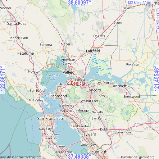
Benicia GPS coordinates[2]
38° 2' 57.732" North, 122° 9' 30.888" West
| Map corner | latitude | longitude |
|---|---|---|
| Upper-left | 38.60097°, | -122.86171° |
| Center: | 38.04937°, | -122.15858° |
| Lower-right: | 37.49358°, | -121.45546° |
| Map W x H: | 123.1×123.1 km | = 76.5×76.5mi |
| max Lat: | 71.29058° ⇑61.3% North |
| Benicia: | 38.04937° |
| min Lat: | ⇓38.7% South 19.06759° |
| min Long | Benicia | max Long |
| -171.73463° | -122.15858° | -66.98998° |
| W 4.5%⇐ | ⇒95.5% E |
Elevation
Elevation of Benicia is 5 m = 16 ft, and this is 289.8 m = 951 ft below average elevation for this country.
| Max E: |
3189 m = 10463 ft | 98.1% |
| Avg. | 294.8 m = 967 ft | |
| Benicia | 5 m = 16 ft | |
Min E: |
-60 m = -197 ft | 1.9% |
See also: United States elevation on elevation.city.
Geographical zone
Benicia is located in North temperate zone (between Tropic of Cancer and the Arctic Circle). Distance of this Northern Tropic circle is 1624.8 km =1009.6 mi to South.| Distance of | km | miles | from Benicia |
|---|---|---|---|
| North Pole | 5776.4 | 3589.3 | to North |
| Arctic Circle | 3170.5 | 1970.1 | to North |
| Tropic Cancer | 1624.8 | 1009.6 | to South |
| Equator | 4230.7 | 2628.8 | to South |


Nearby cities:
15 places around Benicia: (largest is in red/bold)
• Bayview
14.8 km =9.2 mi,  251°
251°
• Clyde
11.6 km =7.2 mi,  103°
103°
• Concord
13.7 km =8.5 mi,  125°
125°
• Crockett
4.8 km =3 mi,  274°
274°
• El Sobrante
14.4 km =8.9 mi,  236°
236°
• Hercules
11.9 km =7.4 mi, 252°
• Martinez
4 km =2.5 mi,  147°
147°
• Mountain View
5.8 km =3.6 mi,  141°
141°
• Pacheco
10.3 km =6.4 mi, 135°
• Pinole
13.3 km =8.3 mi, 247°
• Pleasant Hill
14.2 km =8.8 mi, 142°
• Rodeo
9.7 km =6 mi,  259°
259°
• Tara Hills
15.2 km =9.4 mi, 245°
• Vallejo
10.5 km =6.5 mi,  305°
305°
• Vine Hill
7.1 km =4.4 mi, 129°
Sources, notices
• [Note1] Compared only with cities in United States existing in our database
• [Src1] Map data: © OpenStreetMap contributors (CC-BY-SA)
• [Src2] Other city data from geonames.org with taken over terms of usage.
• [Src3] Geographical zone / Annual Mean Temperature by Robert A. Rohde @ Wikipedia
