Oxnard geodata
Oxnard (California) is a populated place; located in United States in America/Los_Angeles (GMT-7) time zone. With population of 207,254 people, there are 121 cities with bigger population in this country. Compared to other cities in United States, 79% of cities are located further ↑North; 92.1% of cities are located further →East and 88.6% of cities have higher elevation than Oxnard. Note1


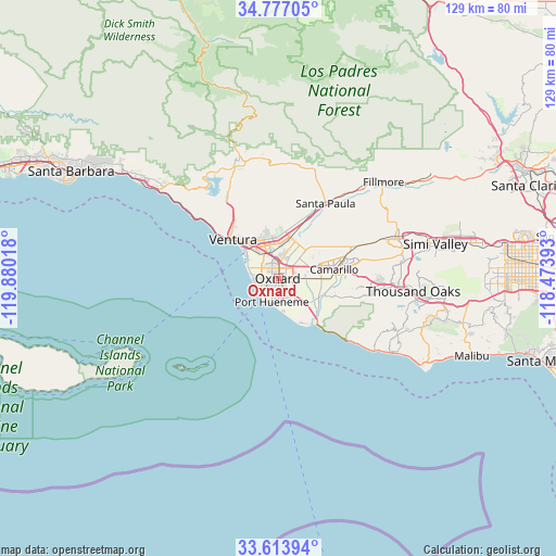
Oxnard GPS coordinates[2]
34° 11' 51" North, 119° 10' 37.38" West
| Map corner | latitude | longitude |
|---|---|---|
| Upper-left | 34.77705°, | -119.88018° |
| Center: | 34.1975°, | -119.17705° |
| Lower-right: | 33.61394°, | -118.47393° |
| Map W x H: | 129.3×129.3 km | = 80.3×80.3mi |
| max Lat: | 71.29058° ⇑79% North |
| Oxnard: | 34.1975° |
| min Lat: | ⇓21% South 19.06759° |
| min Long | Oxnard | max Long |
| -171.73463° | -119.17705° | -66.98998° |
| W 7.9%⇐ | ⇒92.1% E |
Elevation
Elevation of Oxnard is 19 m = 62 ft, and this is 275.8 m = 905 ft below average elevation for this country.
| Max E: |
3189 m = 10463 ft | 88.6% |
| Avg. | 294.8 m = 967 ft | |
| Oxnard | 19 m = 62 ft | |
Min E: |
-60 m = -197 ft | 11.4% |
See also: Oxnard elevation on elevation.city.
Geographical zone
Oxnard is located in North temperate zone (between Tropic of Cancer and the Arctic Circle). Distance of this Northern Tropic circle is 1196.5 km =743.5 mi to South.| Distance of | km | miles | from Oxnard |
|---|---|---|---|
| North Pole | 6204.7 | 3855.4 | to North |
| Arctic Circle | 3598.8 | 2236.2 | to North |
| Tropic Cancer | 1196.5 | 743.5 | to South |
| Equator | 3802.4 | 2362.7 | to South |


Nearby cities:
15 places around Oxnard: (largest is in red/bold)
• Camarillo
13 km =8.1 mi,  80°
80°
• Casa Conejo
21.5 km =13.4 mi,  94°
94°
• Channel Islands Beach
6.1 km =3.8 mi,  224°
224°
• El Rio
4.4 km =2.7 mi,  15°
15°
• Fillmore
32.7 km =20.3 mi,  46°
46°
• Meiners Oaks
29.3 km =18.2 mi,  341°
341°
• Mira Monte
28.1 km =17.5 mi, 339°
• Moorpark
28.8 km =17.9 mi,  70°
70°
• Oak View
25.2 km =15.7 mi,  333°
333°
• Ojai
28.5 km =17.7 mi,  347°
347°
• Port Hueneme
5.8 km =3.6 mi,  196°
196°
• Santa Paula
20.5 km =12.7 mi,  31°
31°
• Saticoy
9.8 km =6.1 mi,  14°
14°
• Thousand Oaks
31.4 km =19.5 mi,  95°
95°
• Ventura
14 km =8.7 mi,  310°
310°
Sources, notices
• [Note1] Compared only with cities in United States existing in our database
• [Src1] Map data: © OpenStreetMap contributors (CC-BY-SA)
• [Src2] Other city data from geonames.org with taken over terms of usage.
• [Src3] Geographical zone / Annual Mean Temperature by Robert A. Rohde @ Wikipedia
