Camarillo geodata
Camarillo (California) is a populated place; located in United States in America/Los_Angeles (GMT-7) time zone. With population of 67,608 people, there are 622 cities with bigger population in this country. Compared to other cities in United States, 78.9% of cities are located further ↑North; 91.9% of cities are located further →East and 78.2% of cities have higher elevation than Camarillo. Note1


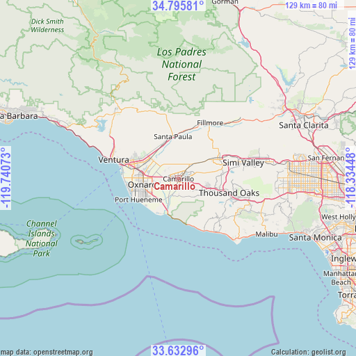
Camarillo GPS coordinates[2]
34° 12' 59.004" North, 119° 2' 15.36" West
| Map corner | latitude | longitude |
|---|---|---|
| Upper-left | 34.79581°, | -119.74073° |
| Center: | 34.21639°, | -119.0376° |
| Lower-right: | 33.63296°, | -118.33448° |
| Map W x H: | 129.3×129.3 km | = 80.3×80.3mi |
| max Lat: | 71.29058° ⇑78.9% North |
| Camarillo: | 34.21639° |
| min Lat: | ⇓21.1% South 19.06759° |
| min Long | Camarillo | max Long |
| -171.73463° | -119.0376° | -66.98998° |
| W 8.1%⇐ | ⇒91.9% E |
Elevation
Elevation of Camarillo is 55 m = 180 ft, and this is 239.8 m = 787 ft below average elevation for this country.
| Max E: |
3189 m = 10463 ft | 78.2% |
| Avg. | 294.8 m = 967 ft | |
| Camarillo | 55 m = 180 ft | |
Min E: |
-60 m = -197 ft | 21.8% |
See also: Camarillo elevation on elevation.city.
Geographical zone
Camarillo is located in North temperate zone (between Tropic of Cancer and the Arctic Circle). Distance of this Northern Tropic circle is 1198.6 km =744.8 mi to South.| Distance of | km | miles | from Camarillo |
|---|---|---|---|
| North Pole | 6202.6 | 3854.1 | to North |
| Arctic Circle | 3596.7 | 2234.9 | to North |
| Tropic Cancer | 1198.6 | 744.8 | to South |
| Equator | 3804.5 | 2364 | to South |


Nearby cities:
15 places around Camarillo: (largest is in red/bold)
• Agoura Hills
25.8 km =16 mi,  110°
110°
• Casa Conejo
9.4 km =5.8 mi, 112°
• Channel Islands Beach
18.3 km =11.4 mi,  249°
249°
• El Rio
11.8 km =7.3 mi,  280°
280°
• Fillmore
23.1 km =14.4 mi,  28°
28°
• Moorpark
16.2 km =10.1 mi,  61°
61°
• Oak Park
25.6 km =15.9 mi,  99°
99°
• Oxnard
13 km =8.1 mi,  260°
260°
• Port Hueneme
16.4 km =10.2 mi,  242°
242°
• Santa Paula
15.4 km =9.6 mi,  352°
352°
• Saticoy
12.7 km =7.9 mi,  305°
305°
• Simi Valley
24.3 km =15.1 mi,  75°
75°
• Thousand Oaks
19.1 km =11.9 mi, 105°
• Ventura
24.5 km =15.2 mi,  286°
286°
• Westlake Village
22.7 km =14.1 mi, 110°
Sources, notices
• [Note1] Compared only with cities in United States existing in our database
• [Src1] Map data: © OpenStreetMap contributors (CC-BY-SA)
• [Src2] Other city data from geonames.org with taken over terms of usage.
• [Src3] Geographical zone / Annual Mean Temperature by Robert A. Rohde @ Wikipedia
