Saticoy geodata
Saticoy (California) is a populated place; located in United States in America/Los_Angeles (GMT-7) time zone. With population of 1,029 people, there are 16082 cities with bigger population in this country. Compared to other cities in United States, 78.5% of cities are located further ↑North; 92% of cities are located further →East and 79.7% of cities have higher elevation than Saticoy. Note1


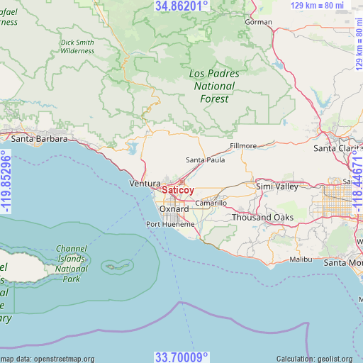
Saticoy GPS coordinates[2]
34° 16' 59.016" North, 119° 8' 59.388" West
| Map corner | latitude | longitude |
|---|---|---|
| Upper-left | 34.86201°, | -119.85296° |
| Center: | 34.28306°, | -119.14983° |
| Lower-right: | 33.70009°, | -118.44671° |
| Map W x H: | 129.2×129.2 km | = 80.3×80.3mi |
| max Lat: | 71.29058° ⇑78.5% North |
| Saticoy: | 34.28306° |
| min Lat: | ⇓21.5% South 19.06759° |
| min Long | Saticoy | max Long |
| -171.73463° | -119.14983° | -66.98998° |
| W 8%⇐ | ⇒92% E |
Elevation
Elevation of Saticoy is 48 m = 157 ft, and this is 246.8 m = 810 ft below average elevation for this country.
| Max E: |
3189 m = 10463 ft | 79.7% |
| Avg. | 294.8 m = 967 ft | |
| Saticoy | 48 m = 157 ft | |
Min E: |
-60 m = -197 ft | 20.3% |
See also: United States elevation on elevation.city.
Geographical zone
Saticoy is located in North temperate zone (between Tropic of Cancer and the Arctic Circle). Distance of this Northern Tropic circle is 1206 km =749.4 mi to South.| Distance of | km | miles | from Saticoy |
|---|---|---|---|
| North Pole | 6195.1 | 3849.5 | to North |
| Arctic Circle | 3589.3 | 2230.3 | to North |
| Tropic Cancer | 1206 | 749.4 | to South |
| Equator | 3811.9 | 2368.6 | to South |


Nearby cities:
15 places around Saticoy: (largest is in red/bold)
• Camarillo
12.7 km =7.9 mi,  125°
125°
• Casa Conejo
22 km =13.7 mi,  120°
120°
• Channel Islands Beach
15.4 km =9.6 mi,  205°
205°
• El Rio
5.4 km =3.4 mi,  193°
193°
• Fillmore
24.9 km =15.5 mi,  58°
58°
• Meiners Oaks
21.8 km =13.5 mi,  326°
326°
• Mira Monte
20.8 km =12.9 mi,  323°
323°
• Moorpark
24.6 km =15.3 mi,  89°
89°
• Oak View
19 km =11.8 mi,  313°
313°
• Ojai
20.2 km =12.6 mi,  335°
335°
• Oxnard
9.8 km =6.1 mi, 194°
• Port Hueneme
15.6 km =9.7 mi,  195°
195°
• Santa Paula
11.5 km =7.1 mi,  46°
46°
• Thousand Oaks
31.3 km =19.4 mi,  113°
113°
• Ventura
13.2 km =8.2 mi,  267°
267°
Sources, notices
• [Note1] Compared only with cities in United States existing in our database
• [Src1] Map data: © OpenStreetMap contributors (CC-BY-SA)
• [Src2] Other city data from geonames.org with taken over terms of usage.
• [Src3] Geographical zone / Annual Mean Temperature by Robert A. Rohde @ Wikipedia
