Vista geodata
Vista (California) is a populated place; located in United States in America/Los_Angeles (GMT-7) time zone. With population of 100,890 people, there are 343 cities with bigger population in this country. Compared to other cities in United States, 84.3% of cities are located further ↑North; 90.1% of cities are located further →East and 69.7% of cities have higher elevation than Vista. Note1


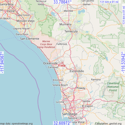
Vista GPS coordinates[2]
33° 12' 0.144" North, 117° 14' 33.144" West
| Map corner | latitude | longitude |
|---|---|---|
| Upper-left | 33.78641°, | -117.94567° |
| Center: | 33.20004°, | -117.24254° |
| Lower-right: | 32.60972°, | -116.53942° |
| Map W x H: | 130.8×130.8 km | = 81.3×81.3mi |
| max Lat: | 71.29058° ⇑84.3% North |
| Vista: | 33.20004° |
| min Lat: | ⇓15.7% South 19.06759° |
| min Long | Vista | max Long |
| -171.73463° | -117.24254° | -66.98998° |
| W 9.9%⇐ | ⇒90.1% E |
Elevation
Elevation of Vista is 102 m = 335 ft, and this is 192.8 m = 633 ft below average elevation for this country.
| Max E: |
3189 m = 10463 ft | 69.7% |
| Avg. | 294.8 m = 967 ft | |
| Vista | 102 m = 335 ft | |
Min E: |
-60 m = -197 ft | 30.3% |
See also: Vista elevation on elevation.city.
Geographical zone
Vista is located in North temperate zone (between Tropic of Cancer and the Arctic Circle). Distance of this Northern Tropic circle is 1085.6 km =674.6 mi to South.| Distance of | km | miles | from Vista |
|---|---|---|---|
| North Pole | 6315.6 | 3924.3 | to North |
| Arctic Circle | 3709.7 | 2305.1 | to North |
| Tropic Cancer | 1085.6 | 674.6 | to South |
| Equator | 3691.5 | 2293.8 | to South |


Nearby cities:
15 places around Vista: (largest is in red/bold)
• Bonsall
10 km =6.2 mi,  9°
9°
• Camp Pendleton North
14.5 km =9 mi,  331°
331°
• Camp Pendleton South
13.1 km =8.1 mi,  283°
283°
• Carlsbad
11.1 km =6.9 mi,  245°
245°
• Encinitas
18.7 km =11.6 mi,  194°
194°
• Escondido
17.1 km =10.6 mi,  121°
121°
• Fallbrook
19.6 km =12.2 mi,  357°
357°
• Hidden Meadows
12.4 km =7.7 mi,  76°
76°
• Hidden Trails
21.5 km =13.4 mi,  108°
108°
• Lake San Marcos
8.8 km =5.5 mi,  158°
158°
• Oceanside
12.7 km =7.9 mi,  267°
267°
• Rancho Santa Fe
20.3 km =12.6 mi,  169°
169°
• San Marcos
9.5 km =5.9 mi,  131°
131°
• Solana Beach
23.4 km =14.5 mi, 186°
• Valley Center
19.5 km =12.1 mi, 83°
Sources, notices
• [Note1] Compared only with cities in United States existing in our database
• [Src1] Map data: © OpenStreetMap contributors (CC-BY-SA)
• [Src2] Other city data from geonames.org with taken over terms of usage.
• [Src3] Geographical zone / Annual Mean Temperature by Robert A. Rohde @ Wikipedia
