Camp Pendleton North geodata
Camp Pendleton North (California) is a populated place; located in United States in America/Los_Angeles (GMT-7) time zone. With population of 5,200 people, there are 7000 cities with bigger population in this country. Compared to other cities in United States, 83.9% of cities are located further ↑North; 90.2% of cities are located further →East and 67.5% of cities have higher elevation than Camp Pendleton North. Note1


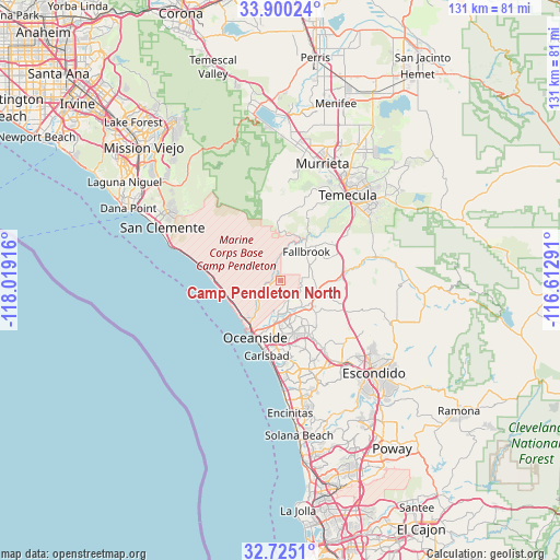
Camp Pendleton North GPS coordinates[2]
33° 18' 52.74" North, 117° 18' 57.708" West
| Map corner | latitude | longitude |
|---|---|---|
| Upper-left | 33.90024°, | -118.01916° |
| Center: | 33.31465°, | -117.31603° |
| Lower-right: | 32.7251°, | -116.61291° |
| Map W x H: | 130.7×130.7 km | = 81.2×81.2mi |
| max Lat: | 71.29058° ⇑83.9% North |
| Camp Pendleton North: | 33.31465° |
| min Lat: | ⇓16.1% South 19.06759° |
| min Long | Camp Pendleton | max Long |
| -171.73463° | -117.31603° | -66.98998° |
| W 9.8%⇐ | ⇒90.2% E |
Elevation
Elevation of Camp Pendleton North is 115 m = 377 ft, and this is 179.8 m = 590 ft below average elevation for this country.
| Max E: |
3189 m = 10463 ft | 67.5% |
| Avg. | 294.8 m = 967 ft | |
| Camp Pendleton North | 115 m = 377 ft | |
Min E: |
-60 m = -197 ft | 32.5% |
See also: United States elevation on elevation.city.
Geographical zone
Camp Pendleton North is located in North temperate zone (between Tropic of Cancer and the Arctic Circle). Distance of this Northern Tropic circle is 1098.3 km =682.5 mi to South.| Distance of | km | miles | from Camp Pendleton North |
|---|---|---|---|
| North Pole | 6302.8 | 3916.4 | to North |
| Arctic Circle | 3696.9 | 2297.1 | to North |
| Tropic Cancer | 1098.3 | 682.5 | to South |
| Equator | 3704.2 | 2301.7 | to South |


Nearby cities:
15 places around Camp Pendleton North: (largest is in red/bold)
• Bonsall
8.9 km =5.5 mi,  108°
108°
• Camp Pendleton South
11.2 km =7 mi,  211°
211°
• Carlsbad
17.7 km =11 mi,  190°
190°
• Escondido
30.5 km =19 mi,  135°
135°
• Fallbrook
9.1 km =5.7 mi,  41°
41°
• Hidden Meadows
21.4 km =13.3 mi,  117°
117°
• Lake San Marcos
23.2 km =14.4 mi,  154°
154°
• Murrieta
28.2 km =17.5 mi,  19°
19°
• Oceanside
14.5 km =9 mi,  204°
204°
• Rainbow
18.9 km =11.7 mi,  55°
55°
• San Clemente
30.2 km =18.8 mi,  294°
294°
• San Marcos
23.6 km =14.7 mi, 143°
• Temecula
25.3 km =15.7 mi, 38°
• Valley Center
28.3 km =17.6 mi, 112°
• Vista
14.5 km =9 mi, 151°
Sources, notices
• [Note1] Compared only with cities in United States existing in our database
• [Src1] Map data: © OpenStreetMap contributors (CC-BY-SA)
• [Src2] Other city data from geonames.org with taken over terms of usage.
• [Src3] Geographical zone / Annual Mean Temperature by Robert A. Rohde @ Wikipedia
