Fallbrook geodata
Fallbrook (California) is a populated place; located in United States in America/Los_Angeles (GMT-7) time zone. With population of 30,534 people, there are 1636 cities with bigger population in this country. Compared to other cities in United States, 83.7% of cities are located further ↑North; 90.1% of cities are located further →East and 53.5% of cities have lower elevation than Fallbrook. Note1


Fallbrook GPS coordinates[2]
33° 22' 35.112" North, 117° 15' 4.14" West
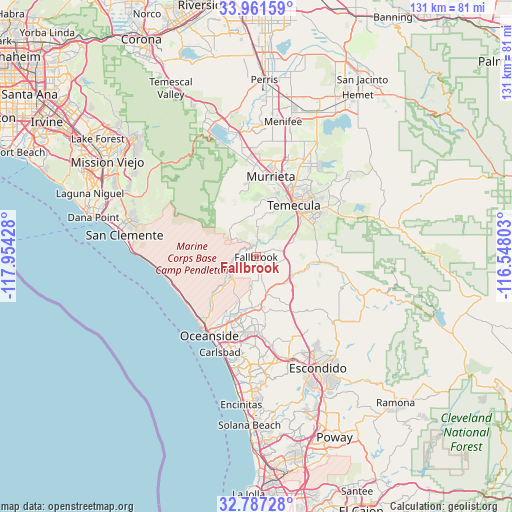
| Map corner | latitude | longitude |
|---|---|---|
| Upper-left | 33.96159°, | -117.95428° |
| Center: | 33.37642°, | -117.25115° |
| Lower-right: | 32.78728°, | -116.54803° |
| Map W x H: | 130.6×130.6 km | = 81.2×81.2mi |
| max Lat: | 71.29058° ⇑83.7% North |
| Fallbrook: | 33.37642° |
| min Lat: | ⇓16.3% South 19.06759° |
| min Long | Fallbrook | max Long |
| -171.73463° | -117.25115° | -66.98998° |
| W 9.9%⇐ | ⇒90.1% E |
Elevation
Elevation of Fallbrook is 212 m = 696 ft, and this is 82.8 m = 272 ft below average elevation for this country.
| Max E: |
3189 m = 10463 ft | 46.5% |
| Avg. | 294.8 m = 967 ft | |
| Fallbrook | 212 m = 696 ft | |
Min E: |
-60 m = -197 ft | 53.5% |
See also: United States elevation on elevation.city.
Geographical zone
Fallbrook is located in North temperate zone (between Tropic of Cancer and the Arctic Circle). Distance of this Northern Tropic circle is 1105.2 km =686.7 mi to South.| Distance of | km | miles | from Fallbrook |
|---|---|---|---|
| North Pole | 6296 | 3912.2 | to North |
| Arctic Circle | 3690.1 | 2292.9 | to North |
| Tropic Cancer | 1105.2 | 686.7 | to South |
| Equator | 3711.1 | 2306 | to South |


Nearby cities:
15 places around Fallbrook: (largest is in red/bold)
• Bonsall
10 km =6.2 mi,  166°
166°
• Camp Pendleton North
9.1 km =5.7 mi,  221°
221°
• Camp Pendleton South
20.3 km =12.6 mi, 215°
• Carlsbad
26 km =16.2 mi,  200°
200°
• Hidden Meadows
21.2 km =13.2 mi,  142°
142°
• Lake San Marcos
28.1 km =17.5 mi, 171°
• Murrieta
20 km =12.4 mi,  9°
9°
• Murrieta Hot Springs
22.2 km =13.8 mi,  22°
22°
• Oceanside
23.4 km =14.5 mi,  210°
210°
• Rainbow
10.3 km =6.4 mi,  68°
68°
• San Marcos
27.1 km =16.8 mi,  163°
163°
• Temecula
16.2 km =10.1 mi,  36°
36°
• Valley Center
26.7 km =16.6 mi,  131°
131°
• Vista
19.6 km =12.2 mi,  177°
177°
• Wildomar
24.9 km =15.5 mi,  353°
353°
Sources, notices
• [Note1] Compared only with cities in United States existing in our database
• [Src1] Map data: © OpenStreetMap contributors (CC-BY-SA)
• [Src2] Other city data from geonames.org with taken over terms of usage.
• [Src3] Geographical zone / Annual Mean Temperature by Robert A. Rohde @ Wikipedia
