Calistoga geodata
Calistoga (California) is a populated place; located in United States in America/Los_Angeles (GMT-7) time zone. With population of 5,330 people, there are 6889 cities with bigger population in this country. Compared to other cities in United States, 58.3% of cities are located further ↑North; 96.9% of cities are located further →East and 68.8% of cities have higher elevation than Calistoga. Note1


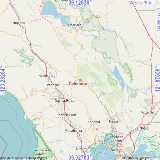
Calistoga GPS coordinates[2]
38° 34' 43.68" North, 122° 34' 46.956" West
| Map corner | latitude | longitude |
|---|---|---|
| Upper-left | 39.12636°, | -123.28284° |
| Center: | 38.5788°, | -122.57971° |
| Lower-right: | 38.02703°, | -121.87659° |
| Map W x H: | 122.2×122.2 km | = 75.9×75.9mi |
| max Lat: | 71.29058° ⇑58.3% North |
| Calistoga: | 38.5788° |
| min Lat: | ⇓41.7% South 19.06759° |
| min Long | Calistoga | max Long |
| -171.73463° | -122.57971° | -66.98998° |
| W 3.1%⇐ | ⇒96.9% E |
Elevation
Elevation of Calistoga is 108 m = 354 ft, and this is 186.8 m = 613 ft below average elevation for this country.
| Max E: |
3189 m = 10463 ft | 68.8% |
| Avg. | 294.8 m = 967 ft | |
| Calistoga | 108 m = 354 ft | |
Min E: |
-60 m = -197 ft | 31.2% |
See also: United States elevation on elevation.city.
Geographical zone
Calistoga is located in North temperate zone (between Tropic of Cancer and the Arctic Circle). Distance of this Northern Tropic circle is 1683.6 km =1046.1 mi to South.| Distance of | km | miles | from Calistoga |
|---|---|---|---|
| North Pole | 5717.5 | 3552.7 | to North |
| Arctic Circle | 3111.6 | 1933.5 | to North |
| Tropic Cancer | 1683.6 | 1046.1 | to South |
| Equator | 4289.6 | 2665.4 | to South |


Nearby cities:
15 places around Calistoga: (largest is in red/bold)
• Angwin
11.3 km =7 mi,  91°
91°
• Deer Park
10.9 km =6.8 mi,  118°
118°
• Eldridge
26.3 km =16.3 mi,  166°
166°
• Fulton
18.9 km =11.7 mi,  241°
241°
• Glen Ellen
24.4 km =15.2 mi, 168°
• Healdsburg
25.4 km =15.8 mi,  277°
277°
• Hidden Valley Lake
25.5 km =15.8 mi,  4°
4°
• Kenwood
18.6 km =11.6 mi, 170°
• Larkfield-Wikiup
16.6 km =10.3 mi, 243°
• Middletown
19.5 km =12.1 mi,  350°
350°
• Roseland
21.7 km =13.5 mi,  216°
216°
• Saint Helena
12.6 km =7.8 mi,  130°
130°
• Santa Rosa
19.3 km =12 mi, 217°
• Windsor
20.9 km =13 mi,  260°
260°
• Yountville
27.4 km =17 mi,  135°
135°
Sources, notices
• [Note1] Compared only with cities in United States existing in our database
• [Src1] Map data: © OpenStreetMap contributors (CC-BY-SA)
• [Src2] Other city data from geonames.org with taken over terms of usage.
• [Src3] Geographical zone / Annual Mean Temperature by Robert A. Rohde @ Wikipedia
