Bennett geodata
Bennett (Colorado) is a populated place; located in United States in America/Denver (GMT-6) time zone. With population of 2,484 people, there are 10659 cities with bigger population in this country. Compared to other cities in United States, 51.2% of cities are located further ↓South; 82.8% of cities are located further →East and 97.8% of cities have lower elevation than Bennett. Note1


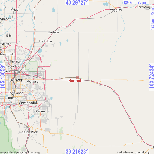
Bennett GPS coordinates[2]
39° 45' 31.932" North, 104° 25' 38.856" West
| Map corner | latitude | longitude |
|---|---|---|
| Upper-left | 40.29727°, | -105.13059° |
| Center: | 39.75887°, | -104.42746° |
| Lower-right: | 39.21623°, | -103.72434° |
| Map W x H: | 120.2×120.2 km | = 74.7×74.7mi |
| max Lat: | 71.29058° ⇑48.8% North |
| Bennett: | 39.75887° |
| min Lat: | ⇓51.2% South 19.06759° |
| min Long | Bennett | max Long |
| -171.73463° | -104.42746° | -66.98998° |
| W 17.2%⇐ | ⇒82.8% E |
Elevation
Elevation of Bennett is 1675 m = 5495 ft, and this is 1380.2 m = 4528 ft above average elevation for this country.
| Max E: |
3189 m = 10463 ft | 2.2% |
| Bennett | 1675 m 5495 ft | |
| Avg. | 294.8 m = 967 ft | |
Min E: |
-60 m = -197 ft | 97.8% |
See also: United States elevation on elevation.city.
Geographical zone
Bennett is located in North temperate zone (between Tropic of Cancer and the Arctic Circle). Distance of this Northern Tropic circle is 1814.9 km =1127.7 mi to South.| Distance of | km | miles | from Bennett |
|---|---|---|---|
| North Pole | 5586.3 | 3471.2 | to North |
| Arctic Circle | 2980.4 | 1851.9 | to North |
| Tropic Cancer | 1814.9 | 1127.7 | to South |
| Equator | 4420.8 | 2747 | to South |


Nearby cities:
15 places around Bennett: (largest is in red/bold)
• Aetna Estates
21.1 km =13.1 mi,  263°
263°
• Aurora
34.7 km =21.6 mi, 264°
• Byers
17.9 km =11.1 mi,  107°
107°
• Cherry Creek
41.3 km =25.7 mi,  250°
250°
• Cottonwood
38.8 km =24.1 mi,  235°
235°
• Deer Trail
36.5 km =22.7 mi,  116°
116°
• Dove Valley
39.9 km =24.8 mi, 239°
• Foxfield
36.4 km =22.6 mi, 239°
• Grand View Estates
41.3 km =25.7 mi,  234°
234°
• Hudson
39.5 km =24.5 mi,  332°
332°
• Keenesburg
39.6 km =24.6 mi,  348°
348°
• Lochbuie
37 km =23 mi,  318°
318°
• Parker
39.1 km =24.3 mi, 226°
• Stonegate
41 km =25.5 mi, 231°
• Strasburg
9.2 km =5.7 mi,  104°
104°
Sources, notices
• [Note1] Compared only with cities in United States existing in our database
• [Src1] Map data: © OpenStreetMap contributors (CC-BY-SA)
• [Src2] Other city data from geonames.org with taken over terms of usage.
• [Src3] Geographical zone / Annual Mean Temperature by Robert A. Rohde @ Wikipedia
