Byers geodata
Byers (Colorado) is a populated place; located in United States in America/Denver (GMT-6) time zone. With population of 1,160 people, there are 15332 cities with bigger population in this country. Compared to other cities in United States, 50.8% of cities are located further ↓South; 82.7% of cities are located further →East and 97.3% of cities have lower elevation than Byers. Note1


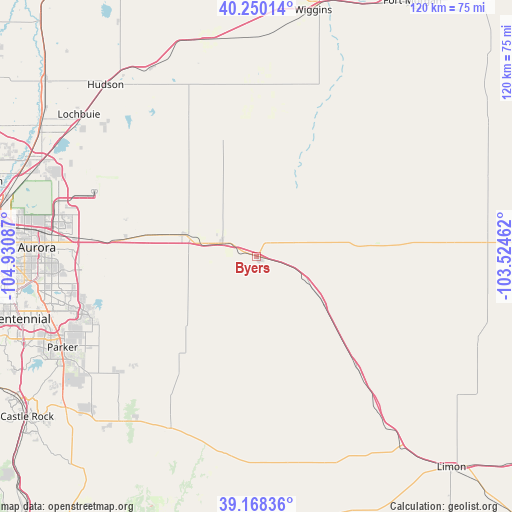
Byers GPS coordinates[2]
39° 42' 40.932" North, 104° 13' 39.864" West
| Map corner | latitude | longitude |
|---|---|---|
| Upper-left | 40.25014°, | -104.93087° |
| Center: | 39.71137°, | -104.22774° |
| Lower-right: | 39.16836°, | -103.52462° |
| Map W x H: | 120.3×120.3 km | = 74.8×74.8mi |
| max Lat: | 71.29058° ⇑49.2% North |
| Byers: | 39.71137° |
| min Lat: | ⇓50.8% South 19.06759° |
| min Long | Byers | max Long |
| -171.73463° | -104.22774° | -66.98998° |
| W 17.3%⇐ | ⇒82.7% E |
Elevation
Elevation of Byers is 1588 m = 5210 ft, and this is 1293.2 m = 4243 ft above average elevation for this country.
| Max E: |
3189 m = 10463 ft | 2.7% |
| Byers | 1588 m 5210 ft | |
| Avg. | 294.8 m = 967 ft | |
Min E: |
-60 m = -197 ft | 97.3% |
See also: United States elevation on elevation.city.
Geographical zone
Byers is located in North temperate zone (between Tropic of Cancer and the Arctic Circle). Distance of this Northern Tropic circle is 1809.6 km =1124.4 mi to South.| Distance of | km | miles | from Byers |
|---|---|---|---|
| North Pole | 5591.6 | 3474.5 | to North |
| Arctic Circle | 2985.7 | 1855.2 | to North |
| Tropic Cancer | 1809.6 | 1124.4 | to South |
| Equator | 4415.5 | 2743.7 | to South |


Nearby cities:
15 places around Byers: (largest is in red/bold)
• Aetna Estates
38.2 km =23.7 mi,  274°
274°
• Aurora
51.7 km =32.1 mi, 272°
• Bennett
17.9 km =11.1 mi,  287°
287°
• Cottonwood
51.9 km =32.2 mi,  251°
251°
• Deer Trail
19 km =11.8 mi,  124°
124°
• Elizabeth
50.3 km =31.3 mi,  219°
219°
• Foxfield
50.1 km =31.1 mi, 254°
• Keenesburg
50.7 km =31.5 mi,  330°
330°
• Kiowa
45.3 km =28.1 mi,  206°
206°
• Lochbuie
53.1 km =33 mi,  308°
308°
• Parker
50.5 km =31.4 mi,  244°
244°
• Ponderosa Park
49.5 km =30.8 mi,  227°
227°
• Stonegate
53.3 km =33.1 mi, 247°
• Strasburg
8.7 km =5.4 mi, 290°
• The Pinery
51.9 km =32.2 mi, 236°
Sources, notices
• [Note1] Compared only with cities in United States existing in our database
• [Src1] Map data: © OpenStreetMap contributors (CC-BY-SA)
• [Src2] Other city data from geonames.org with taken over terms of usage.
• [Src3] Geographical zone / Annual Mean Temperature by Robert A. Rohde @ Wikipedia
