La Veta geodata
La Veta (Colorado) is a populated place; located in United States in America/Denver (GMT-6) time zone. With population of 759 people, there are 18140 cities with bigger population in this country. Compared to other cities in United States, 64% of cities are located further ↑North; 83.3% of cities are located further →East and 99.5% of cities have lower elevation than La Veta. Note1


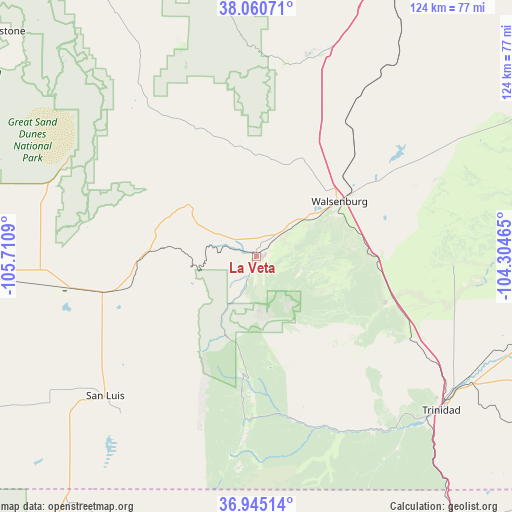
La Veta GPS coordinates[2]
37° 30' 18.036" North, 105° 0' 27.972" West
| Map corner | latitude | longitude |
|---|---|---|
| Upper-left | 38.06071°, | -105.7109° |
| Center: | 37.50501°, | -105.00777° |
| Lower-right: | 36.94514°, | -104.30465° |
| Map W x H: | 124×124 km | = 77.1×77.1mi |
| max Lat: | 71.29058° ⇑64% North |
| La Veta: | 37.50501° |
| min Lat: | ⇓36% South 19.06759° |
| min Long | La Veta | max Long |
| -171.73463° | -105.00777° | -66.98998° |
| W 16.7%⇐ | ⇒83.3% E |
Elevation
Elevation of La Veta is 2150 m = 7054 ft, and this is 1855.2 m = 6087 ft above average elevation for this country.
| Max E: |
3189 m = 10463 ft | 0.5% |
| La Veta | 2150 m 7054 ft | |
| Avg. | 294.8 m = 967 ft | |
Min E: |
-60 m = -197 ft | 99.5% |
See also: United States elevation on elevation.city.
Geographical zone
La Veta is located in North temperate zone (between Tropic of Cancer and the Arctic Circle). Distance of this Northern Tropic circle is 1564.2 km =971.9 mi to South.| Distance of | km | miles | from La Veta |
|---|---|---|---|
| North Pole | 5836.9 | 3626.9 | to North |
| Arctic Circle | 3231 | 2007.6 | to North |
| Tropic Cancer | 1564.2 | 971.9 | to South |
| Equator | 4170.2 | 2591.2 | to South |


Nearby cities:
15 places around La Veta: (largest is in red/bold)
• Alamosa
76.2 km =47.3 mi,  267°
267°
• Alamosa East
73.7 km =45.8 mi, 267°
• Beulah Valley
63.2 km =39.3 mi,  3°
3°
• Colorado City
51.3 km =31.9 mi,  17°
17°
• La Jara
87.9 km =54.6 mi,  253°
253°
• Manassa
90 km =55.9 mi, 245°
• Pueblo
90.4 km =56.2 mi, 22°
• Raton
83.7 km =52 mi,  143°
143°
• Salt Creek
89.5 km =55.6 mi, 24°
• San Luis
50 km =31.1 mi,  227°
227°
• Sanford
83.9 km =52.1 mi, 250°
• Silver Cliff
80 km =49.7 mi,  331°
331°
• Trinidad
58.3 km =36.2 mi,  129°
129°
• Walsenburg
24 km =14.9 mi,  56°
56°
• Westcliffe
80.8 km =50.2 mi, 330°
Sources, notices
• [Note1] Compared only with cities in United States existing in our database
• [Src1] Map data: © OpenStreetMap contributors (CC-BY-SA)
• [Src2] Other city data from geonames.org with taken over terms of usage.
• [Src3] Geographical zone / Annual Mean Temperature by Robert A. Rohde @ Wikipedia
