Trinidad geodata
Trinidad (Colorado) is a seat of a second-order administrative division; located in United States in America/Denver (GMT-6) time zone. With population of 8,153 people, there are 5216 cities with bigger population in this country. Compared to other cities in United States, 65.4% of cities are located further ↑North; 82.8% of cities are located further →East and 98.6% of cities have lower elevation than Trinidad. Note1


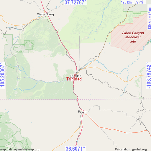
Trinidad GPS coordinates[2]
37° 10' 10.056" North, 104° 30' 1.944" West
| Map corner | latitude | longitude |
|---|---|---|
| Upper-left | 37.72767°, | -105.20367° |
| Center: | 37.16946°, | -104.50054° |
| Lower-right: | 36.6071°, | -103.79742° |
| Map W x H: | 124.6×124.6 km | = 77.4×77.4mi |
| max Lat: | 71.29058° ⇑65.4% North |
| Trinidad: | 37.16946° |
| min Lat: | ⇓34.6% South 19.06759° |
| min Long | Trinidad | max Long |
| -171.73463° | -104.50054° | -66.98998° |
| W 17.2%⇐ | ⇒82.8% E |
Elevation
Elevation of Trinidad is 1844 m = 6050 ft, and this is 1549.2 m = 5083 ft above average elevation for this country.
| Max E: |
3189 m = 10463 ft | 1.4% |
| Trinidad | 1844 m 6050 ft | |
| Avg. | 294.8 m = 967 ft | |
Min E: |
-60 m = -197 ft | 98.6% |
See also: United States elevation on elevation.city.
Geographical zone
Trinidad is located in North temperate zone (between Tropic of Cancer and the Arctic Circle). Distance of this Northern Tropic circle is 1526.9 km =948.8 mi to South.| Distance of | km | miles | from Trinidad |
|---|---|---|---|
| North Pole | 5874.2 | 3650.1 | to North |
| Arctic Circle | 3268.3 | 2030.8 | to North |
| Tropic Cancer | 1526.9 | 948.8 | to South |
| Equator | 4132.9 | 2568.1 | to South |


Nearby cities:
15 places around Trinidad: (largest is in red/bold)
• Angel Fire
111.1 km =69 mi,  218°
218°
• Arroyo Seco
119.6 km =74.3 mi,  232°
232°
• Avondale
119.5 km =74.3 mi,  6°
6°
• Beulah Valley
108.4 km =67.4 mi,  337°
337°
• Blende
119.8 km =74.4 mi,  357°
357°
• Cimarron
82 km =51 mi,  206°
206°
• Colorado City
91.2 km =56.7 mi, 341°
• Fowler
114.7 km =71.3 mi,  21°
21°
• La Veta
58.3 km =36.2 mi,  309°
309°
• Questa
110.2 km =68.5 mi,  241°
241°
• Raton
30.1 km =18.7 mi,  169°
169°
• Salt Creek
119.1 km =74 mi, 356°
• San Luis
81.9 km =50.9 mi,  272°
272°
• Springer
90.3 km =56.1 mi,  185°
185°
• Walsenburg
56.3 km =35 mi,  333°
333°
Sources, notices
• [Note1] Compared only with cities in United States existing in our database
• [Src1] Map data: © OpenStreetMap contributors (CC-BY-SA)
• [Src2] Other city data from geonames.org with taken over terms of usage.
• [Src3] Geographical zone / Annual Mean Temperature by Robert A. Rohde @ Wikipedia
