Pueblo geodata
Pueblo (Colorado) is a seat of a second-order administrative division; located in United States in America/Denver (GMT-6) time zone. With population of 109,412 people, there are 309 cities with bigger population in this country. Compared to other cities in United States, 60.3% of cities are located further ↑North; 82.9% of cities are located further →East and 96.2% of cities have lower elevation than Pueblo. Note1


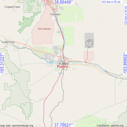
Pueblo GPS coordinates[2]
38° 15' 16.02" North, 104° 36' 32.904" West
| Map corner | latitude | longitude |
|---|---|---|
| Upper-left | 38.80449°, | -105.31227° |
| Center: | 38.25445°, | -104.60914° |
| Lower-right: | 37.70021°, | -103.90602° |
| Map W x H: | 122.8×122.8 km | = 76.3×76.3mi |
| max Lat: | 71.29058° ⇑60.3% North |
| Pueblo: | 38.25445° |
| min Lat: | ⇓39.7% South 19.06759° |
| min Long | Pueblo | max Long |
| -171.73463° | -104.60914° | -66.98998° |
| W 17.1%⇐ | ⇒82.9% E |
Elevation
Elevation of Pueblo is 1430 m = 4692 ft, and this is 1135.2 m = 3724 ft above average elevation for this country.
| Max E: |
3189 m = 10463 ft | 3.8% |
| Pueblo | 1430 m 4692 ft | |
| Avg. | 294.8 m = 967 ft | |
Min E: |
-60 m = -197 ft | 96.2% |
See also: Pueblo elevation on elevation.city.
Geographical zone
Pueblo is located in North temperate zone (between Tropic of Cancer and the Arctic Circle). Distance of this Northern Tropic circle is 1647.6 km =1023.8 mi to South.| Distance of | km | miles | from Pueblo |
|---|---|---|---|
| North Pole | 5753.6 | 3575.1 | to North |
| Arctic Circle | 3147.7 | 1955.9 | to North |
| Tropic Cancer | 1647.6 | 1023.8 | to South |
| Equator | 4253.5 | 2643 | to South |


Nearby cities:
15 places around Pueblo: (largest is in red/bold)
• Avondale
22.6 km =14 mi,  94°
94°
• Beulah Valley
37.2 km =23.1 mi,  237°
237°
• Blende
3.7 km =2.3 mi,  105°
105°
• Cañon City
59 km =36.7 mi,  290°
290°
• Colorado City
39.7 km =24.7 mi,  209°
209°
• Florence
46.9 km =29.1 mi, 288°
• Fort Carson
55.9 km =34.7 mi,  343°
343°
• Fountain
48.2 km =30 mi,  350°
350°
• Fowler
53.1 km =33 mi, 105°
• Lincoln Park
56.7 km =35.2 mi, 290°
• Penrose
40.8 km =25.4 mi,  297°
297°
• Pueblo West
14.5 km =9 mi,  316°
316°
• Salt Creek
2.6 km =1.6 mi,  132°
132°
• Security-Widefield
55.6 km =34.5 mi, 350°
• Williamsburg
49.4 km =30.7 mi, 286°
Sources, notices
• [Note1] Compared only with cities in United States existing in our database
• [Src1] Map data: © OpenStreetMap contributors (CC-BY-SA)
• [Src2] Other city data from geonames.org with taken over terms of usage.
• [Src3] Geographical zone / Annual Mean Temperature by Robert A. Rohde @ Wikipedia
