Boulder geodata
Boulder (Colorado) is a seat of a second-order administrative division; located in United States in America/Denver (GMT-6) time zone. With population of 107,349 people, there are 319 cities with bigger population in this country. Compared to other cities in United States, 53.7% of cities are located further ↓South; 83.5% of cities are located further →East and 97.5% of cities have lower elevation than Boulder. Note1


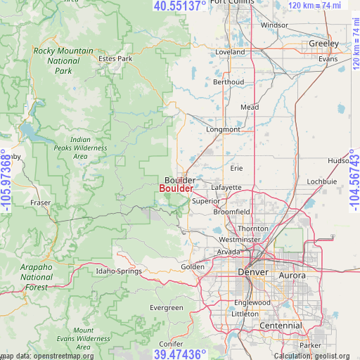
Boulder GPS coordinates[2]
40° 0' 53.964" North, 105° 16' 13.98" West
| Map corner | latitude | longitude |
|---|---|---|
| Upper-left | 40.55137°, | -105.97368° |
| Center: | 40.01499°, | -105.27055° |
| Lower-right: | 39.47436°, | -104.56743° |
| Map W x H: | 119.8×119.8 km | = 74.4×74.4mi |
| max Lat: | 71.29058° ⇑46.3% North |
| Boulder: | 40.01499° |
| min Lat: | ⇓53.7% South 19.06759° |
| min Long | Boulder | max Long |
| -171.73463° | -105.27055° | -66.98998° |
| W 16.5%⇐ | ⇒83.5% E |
Elevation
Elevation of Boulder is 1630 m = 5348 ft, and this is 1335.2 m = 4381 ft above average elevation for this country.
| Max E: |
3189 m = 10463 ft | 2.5% |
| Boulder | 1630 m 5348 ft | |
| Avg. | 294.8 m = 967 ft | |
Min E: |
-60 m = -197 ft | 97.5% |
See also: Boulder elevation on elevation.city.
Geographical zone
Boulder is located in North temperate zone (between Tropic of Cancer and the Arctic Circle). Distance of this Northern Tropic circle is 1843.3 km =1145.4 mi to South.| Distance of | km | miles | from Boulder |
|---|---|---|---|
| North Pole | 5557.8 | 3453.5 | to North |
| Arctic Circle | 2951.9 | 1834.2 | to North |
| Tropic Cancer | 1843.3 | 1145.4 | to South |
| Equator | 4449.2 | 2764.6 | to South |


Nearby cities:
15 places around Boulder: (largest is in red/bold)
• Altona
13.3 km =8.3 mi,  355°
355°
• Broomfield
18.9 km =11.7 mi,  123°
123°
• Coal Creek
15.1 km =9.4 mi,  217°
217°
• Eldorado Springs
9.2 km =5.7 mi,  183°
183°
• Erie
19.2 km =11.9 mi,  78°
78°
• Gunbarrel
10 km =6.2 mi,  57°
57°
• Lafayette
15.6 km =9.7 mi,  98°
98°
• Lazy Acres
10.2 km =6.3 mi,  328°
328°
• Longmont
22.2 km =13.8 mi,  40°
40°
• Louisville
12.5 km =7.8 mi,  109°
109°
• Nederland
21.3 km =13.2 mi,  253°
253°
• Niwot
13 km =8.1 mi, 40°
• Paragon Estates
9 km =5.6 mi, 114°
• Pine Brook Hill
5.4 km =3.4 mi,  315°
315°
• Superior
11.1 km =6.9 mi,  128°
128°
Sources, notices
• [Note1] Compared only with cities in United States existing in our database
• [Src1] Map data: © OpenStreetMap contributors (CC-BY-SA)
• [Src2] Other city data from geonames.org with taken over terms of usage.
• [Src3] Geographical zone / Annual Mean Temperature by Robert A. Rohde @ Wikipedia
