Thornton geodata
Thornton (Colorado) is a populated place; located in United States in America/Denver (GMT-6) time zone. With population of 133,451 people, there are 225 cities with bigger population in this country. Compared to other cities in United States, 52.2% of cities are located further ↓South; 83.3% of cities are located further →East and 97.6% of cities have lower elevation than Thornton. Note1


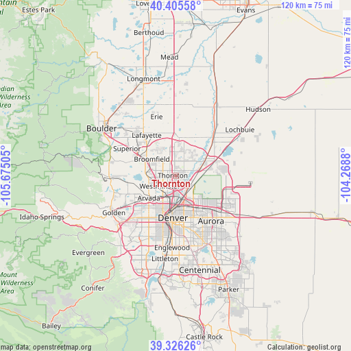
Thornton GPS coordinates[2]
39° 52' 4.944" North, 104° 58' 18.912" West
| Map corner | latitude | longitude |
|---|---|---|
| Upper-left | 40.40558°, | -105.67505° |
| Center: | 39.86804°, | -104.97192° |
| Lower-right: | 39.32626°, | -104.2688° |
| Map W x H: | 120×120 km | = 74.6×74.6mi |
| max Lat: | 71.29058° ⇑47.8% North |
| Thornton: | 39.86804° |
| min Lat: | ⇓52.2% South 19.06759° |
| min Long | Thornton | max Long |
| -171.73463° | -104.97192° | -66.98998° |
| W 16.7%⇐ | ⇒83.3% E |
Elevation
Elevation of Thornton is 1635 m = 5364 ft, and this is 1340.2 m = 4397 ft above average elevation for this country.
| Max E: |
3189 m = 10463 ft | 2.4% |
| Thornton | 1635 m 5364 ft | |
| Avg. | 294.8 m = 967 ft | |
Min E: |
-60 m = -197 ft | 97.6% |
See also: Thornton elevation on elevation.city.
Geographical zone
Thornton is located in North temperate zone (between Tropic of Cancer and the Arctic Circle). Distance of this Northern Tropic circle is 1827 km =1135.2 mi to South.| Distance of | km | miles | from Thornton |
|---|---|---|---|
| North Pole | 5574.2 | 3463.6 | to North |
| Arctic Circle | 2968.3 | 1844.4 | to North |
| Tropic Cancer | 1827 | 1135.2 | to South |
| Equator | 4432.9 | 2754.5 | to South |


Nearby cities:
15 places around Thornton: (largest is in red/bold)
• Arvada
12.2 km =7.6 mi,  233°
233°
• Berkley
8.5 km =5.3 mi,  213°
213°
• Broomfield
11.4 km =7.1 mi,  300°
300°
• Commerce City
7.4 km =4.6 mi,  153°
153°
• Denver
14.4 km =8.9 mi,  184°
184°
• Derby
5.6 km =3.5 mi,  124°
124°
• Federal Heights
2.9 km =1.8 mi, 230°
• Mountain View
12.6 km =7.8 mi, 214°
• Northglenn
2.3 km =1.4 mi,  326°
326°
• Shaw Heights
6.3 km =3.9 mi,  254°
254°
• Sherrelwood
4.2 km =2.6 mi,  216°
216°
• Twin Lakes
5.5 km =3.4 mi, 210°
• Welby
3.7 km =2.3 mi,  162°
162°
• Westminster
6.6 km =4.1 mi,  237°
237°
• Wheat Ridge
14.5 km =9 mi, 218°
Sources, notices
• [Note1] Compared only with cities in United States existing in our database
• [Src1] Map data: © OpenStreetMap contributors (CC-BY-SA)
• [Src2] Other city data from geonames.org with taken over terms of usage.
• [Src3] Geographical zone / Annual Mean Temperature by Robert A. Rohde @ Wikipedia
