Broomfield geodata
Broomfield (Colorado) is a seat of a second-order administrative division; located in United States in America/Denver (GMT-6) time zone. With population of 65,065 people, there are 659 cities with bigger population in this country. Compared to other cities in United States, 52.7% of cities are located further ↓South; 83.4% of cities are located further →East and 97.7% of cities have lower elevation than Broomfield. Note1


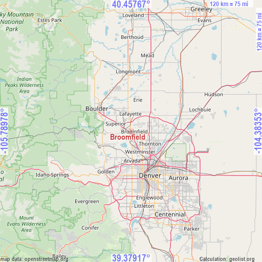
Broomfield GPS coordinates[2]
39° 55' 13.944" North, 105° 5' 11.94" West
| Map corner | latitude | longitude |
|---|---|---|
| Upper-left | 40.45767°, | -105.78978° |
| Center: | 39.92054°, | -105.08665° |
| Lower-right: | 39.37917°, | -104.38353° |
| Map W x H: | 119.9×119.9 km | = 74.5×74.5mi |
| max Lat: | 71.29058° ⇑47.3% North |
| Broomfield: | 39.92054° |
| min Lat: | ⇓52.7% South 19.06759° |
| min Long | Broomfield | max Long |
| -171.73463° | -105.08665° | -66.98998° |
| W 16.6%⇐ | ⇒83.4% E |
Elevation
Elevation of Broomfield is 1649 m = 5410 ft, and this is 1354.2 m = 4443 ft above average elevation for this country.
| Max E: |
3189 m = 10463 ft | 2.3% |
| Broomfield | 1649 m 5410 ft | |
| Avg. | 294.8 m = 967 ft | |
Min E: |
-60 m = -197 ft | 97.7% |
See also: Broomfield elevation on elevation.city.
Geographical zone
Broomfield is located in North temperate zone (between Tropic of Cancer and the Arctic Circle). Distance of this Northern Tropic circle is 1832.8 km =1138.8 mi to South.| Distance of | km | miles | from Broomfield |
|---|---|---|---|
| North Pole | 5568.3 | 3460 | to North |
| Arctic Circle | 2962.4 | 1840.7 | to North |
| Tropic Cancer | 1832.8 | 1138.8 | to South |
| Equator | 4438.7 | 2758.1 | to South |


Nearby cities:
15 places around Broomfield: (largest is in red/bold)
• Arvada
13.1 km =8.1 mi,  180°
180°
• Berkley
13.9 km =8.6 mi,  158°
158°
• Erie
14.8 km =9.2 mi,  12°
12°
• Federal Heights
10.8 km =6.7 mi,  135°
135°
• Lafayette
8.1 km =5 mi,  358°
358°
• Louisville
7.4 km =4.6 mi,  328°
328°
• Northglenn
9.3 km =5.8 mi,  114°
114°
• Paragon Estates
10.1 km =6.3 mi,  312°
312°
• Shaw Heights
8.4 km =5.2 mi,  153°
153°
• Sherrelwood
11.7 km =7.3 mi, 141°
• Superior
7.9 km =4.9 mi,  297°
297°
• Thornton
11.4 km =7.1 mi,  120°
120°
• Twin Lakes
12.7 km =7.9 mi, 146°
• Welby
14.3 km =8.9 mi,  130°
130°
• Westminster
10.2 km =6.3 mi, 155°
Sources, notices
• [Note1] Compared only with cities in United States existing in our database
• [Src1] Map data: © OpenStreetMap contributors (CC-BY-SA)
• [Src2] Other city data from geonames.org with taken over terms of usage.
• [Src3] Geographical zone / Annual Mean Temperature by Robert A. Rohde @ Wikipedia
